
Opinion: A regional rail solution to relieve long-term capacity constraints on SkyTrain's Expo Line

Written for Daily Hive Urbanized by North Vancouver resident and public transit and active transportation enthusiast Johnathan French.
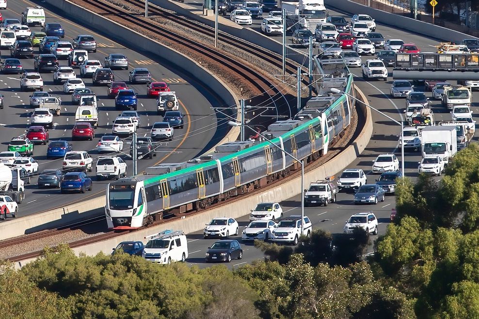
We need to start thinking about the long-term need to build a relief line for Metro Vancouver’s original SkyTrain line, the Expo Line.
It is perpetually overcrowded, and even additional future orders of the new five-car Mark V trains that fully span the 80-metre length of the Expo Line’s station platforms at maximum frequencies will not provide enough capacity over the coming decades.
In fact, TransLink’s Transport 2050 Plan and the City of Vancouver’s forthcoming Official Development Plan highlight the need for very significant capacity boosts for SkyTrain’s Expo Line and Canada Line over the coming decades to meet demand, with both lines set to reach their respective ultimate design capacities by the middle of the century. These strategic plans suggest the possibility of building parallel lines, double tracking, and/or increasing service frequency and/or train capacity.
It is well established that the Expo Line has a maximum design capacity of about 25,000 passengers per hour per direction (pphpd), achieved through the introduction of longer trains that fill the entire platform length — something the incoming fleet of Mark V trains accomplishes — and by operating at maximum frequency, with trains running approximately every minute. TransLink told Daily Hive Urbanized that in 2025, the Expo Line had a peak-hour capacity of 14,400 pphpd, and that by 2030 this will increase to 17,000 pphpd through the expanded use of Mark V trains that have already been ordered.
Prior to any major interventions, this leaves roughly 8,000 pphpd of remaining potential peak capacity, which is not enough for long-term needs in a rapidly growing region with high-density, transit-oriented development around SkyTrain stations.
Right now, the Expo Line’s peak hour trains running at very high frequencies are often already full, and this will only get worse as we continue to build new housing along the line.
Simply put, high-density, transit-oriented development will not work if commuters get passed up by full trains.
Even so, it is difficult to justify a relief line when the rest of the region also needs public transit investments. Therefore, we should design this new relief line to allow for future expansions far beyond Vancouver and Surrey.
- You might also like:
- Cancelled 10-lane George Massey Bridge plan was designed to enable future new SkyTrain line
- How to better control the spiralling construction costs of Canada's public transit projects
- Montreal has opened a massive SkyTrain-inspired driverless train network (PHOTOS)
- 8-km-long Highway 1 widening in Abbotsford to cost $2.65 billion
- Opinion: TransLink and BC Transit should use the same digital fare payment system
- Opinion: Why this TransLink bus exchange in Surrey needs to be relocated
- Opinion: SkyTrain's future is at an uncertain crossroads after 40 years of success
This does not have to be just another SkyTrain line. Rather, it should be a high-capacity regional rail backbone, built to handle 200-metre-long trains, and to connect people over much greater distances at higher speeds.
Building this kind of infrastructure might sound like a monumental endeavour. The distance between Surrey City Centre and downtown Vancouver is over 22 km as the crow flies, and the route passes through densely populated areas.
Mountain Valley Institute, a non-profit public transit research and advocacy organization previously known as Mountain Valley Express, has already put together some preliminary work detailing how and why a comprehensive regional rail network should be built in Metro Vancouver.
They make a compelling argument, but I want to go a step further and demonstrate how we could build an initial segment connecting Surrey to Vancouver, theoretically for less than the cost of the current project of building the Surrey-Langley SkyTrain extension.
This should be possible if we use the Port Mann Bridge, and the middle lanes and/or median of Highway 1.
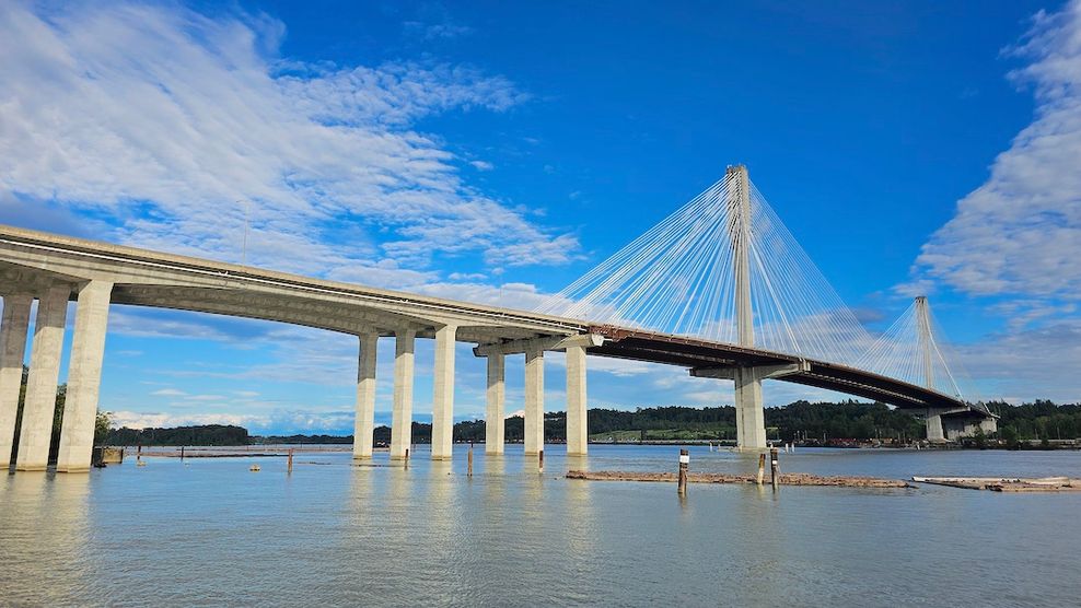
Port Mann Bridge. (Kenneth Chan)
When the new Port Mann Bridge was built in 2012, it was designed to accommodate a future passenger rail line. The structure was built to handle forms of light rail (like SkyTrain), and this could provide us with a cheap and easy way across the Fraser River, as building new tunnels and bridges for this train service would be expensive. We should avoid these costly construction methods if possible, and try to re-use existing infrastructure.
Keep in mind — this is merely a hypothetical alignment meant to demonstrate how this kind of infrastructure might be built.
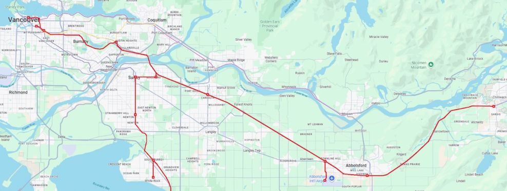
An extremely hypothetical regional rail concept for the Expo Line’s relief line
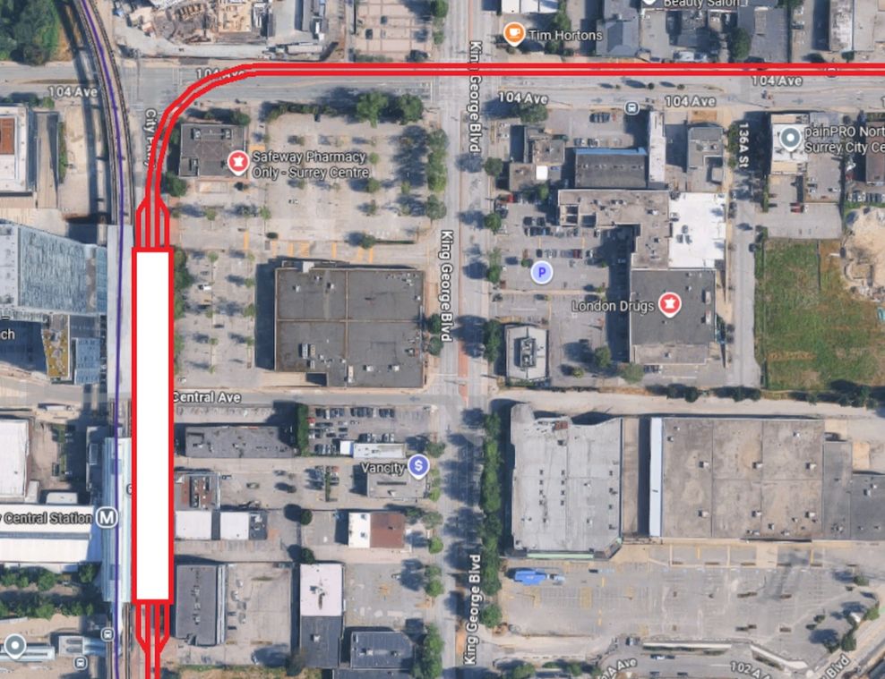
Let us start the relief line at Surrey Central Station, right next to the existing SkyTrain station on City Parkway.
This elevated station would serve as the southern terminus of the new line, but we would include tail tracks to potentially extend the line further south in the future. This station should be built to handle express trains in the future. Long-term, we could build an extension down to Newton and White Rock.
For now though, the idea is to give today’s Expo Line passengers a faster and higher capacity rapid transit option.
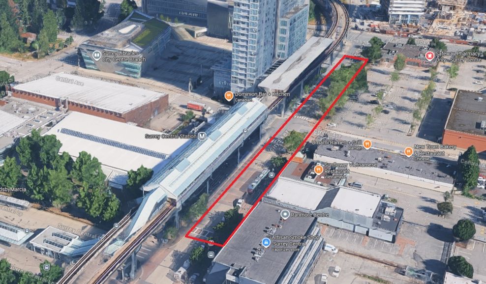
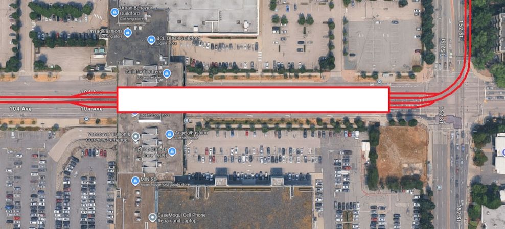
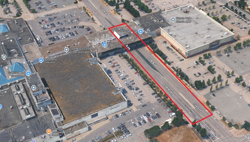
The new line would continue east on 104th Avenue via elevated tracks for 3.5 km until it reaches Guildford Town Centre. Here, we would build another four-track station next to the shopping mall.
We might be able to work with the mall, ideally integrating the station into the building; if that is too expensive, we would place the station further west and have the guideway pass over the mall. We could also consider building on one of the parking lots instead, which would simplify station construction.
That said, we will generally try to build elevated guideways over streets and roads to avoid costly expropriation, even if it means removing lanes. The new line would more than make up for the reduced car capacity.
Johnathan French/Google Maps
Johnathan French/Google Maps
Johnathan French/Google Maps
Johnathan French/Google Maps
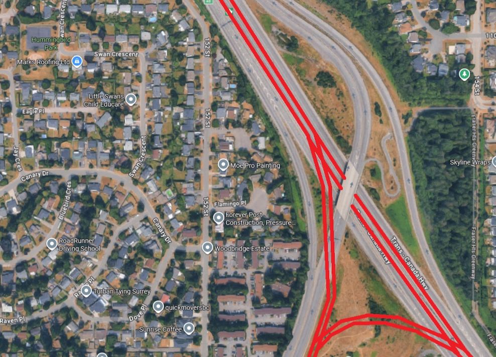
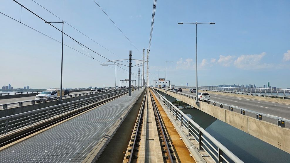
We would turn north onto 152nd Street, continuing via an elevated guideway for a little over one km before finally arriving at Highway 1 and the Port Mann Bridge. Here, we would merge into the centre lanes of Highway 1, and use the Port Mann Bridge to cross the Fraser River. Again, this should be possible because the bridge was designed with passenger rail in mind. This would avoid the need to build a costly new rail bridge over the wide point of river. We would also want to add a three-way junction here, to allow for a future expansion eastward down Highway 1.
Once over the Port Mann Bridge, we would continue westward via the centre of Highway 1. This will also save us a huge amount of money, as we would not need to construct any elevated guideways or tunnels while on the highway — just track ballast, railway, overhead catenary power lines, and concrete barriers. We would lose at least two vehicle lanes along the highway, but we would gain an inexpensive regional rail link, allowing us to move more people overall.
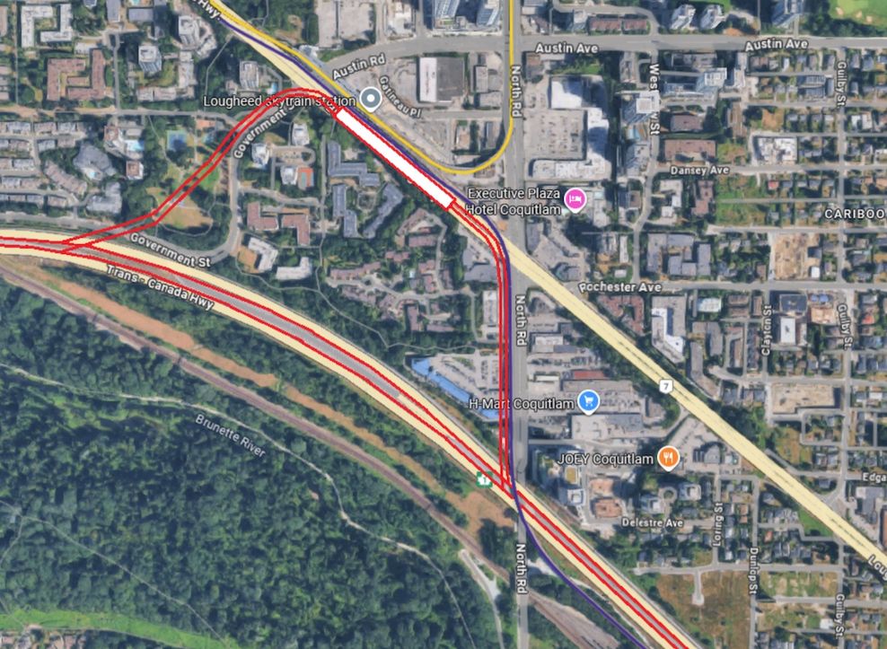
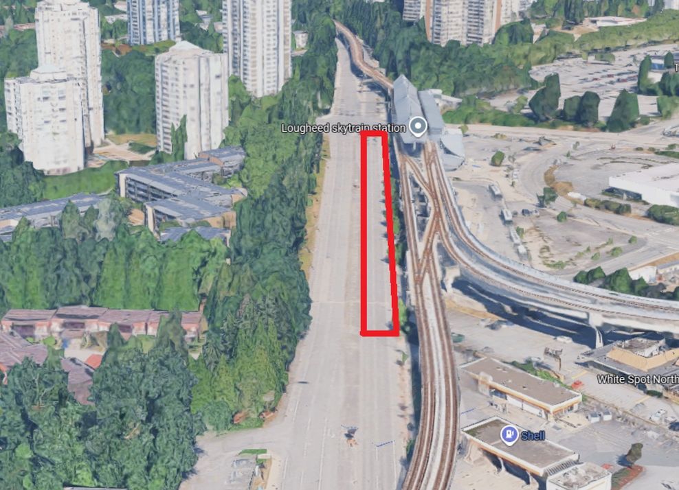
Next, we would connect to Lougheed Town Centre, where we could allow passengers to transfer to and from SkyTrain’s Expo and Millennium lines.
Express trains would continue down Highway 1, while local trains would stop here. This station would require 1.3 km of new elevated guideways, along with track switches and overpasses; there is also a bus underpass on Government Street that would require modifications. This would all add to costs, but an optimal SkyTrain connection is hard to skip.
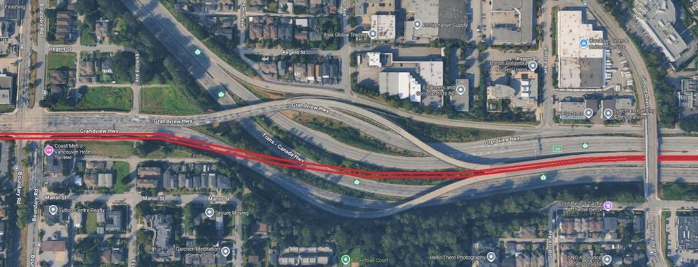
The tracks would continue westward along Highway 1 until just past Gilmore Avenue. At this location, we would go elevated again, eventually reaching Grandview Highway. We would try to keep the relief line as straight as possible to avoid slowing down.
Johnathan French/Google Maps
Johnathan French/Google Maps
Johnathan French/Google Maps
Johnathan French/Google Maps
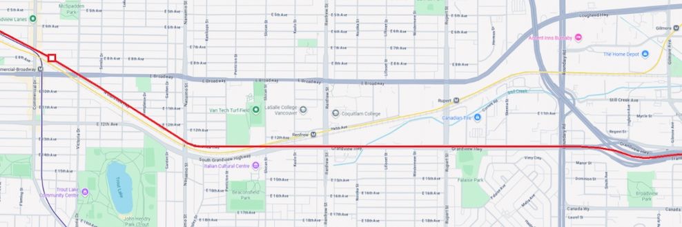
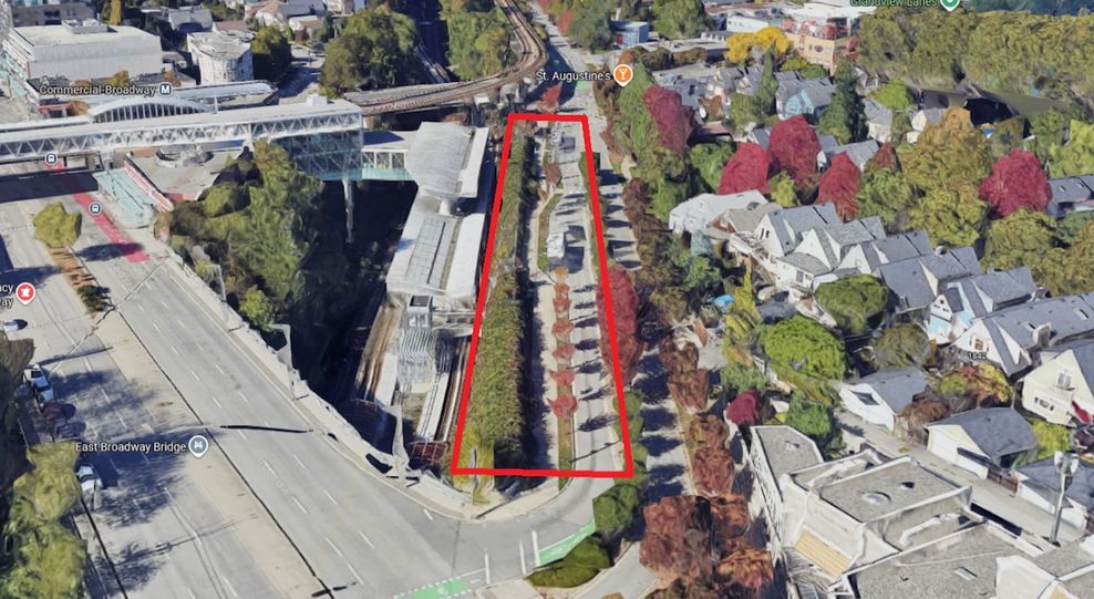
Continuing west, we would pass above the Millennium Line and go along North Grandview Highway and the Central Valley Greenway.
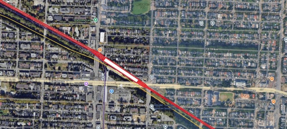
We would then arrive just north of SkyTrain’s Commercial-Broadway Station, where another elevated station would be built, with connections to the platforms on the Expo and Millennium lines.
There should be enough room on North Grandview Highway to accommodate an elevated four-track station while still maintaining the bus stops, sidewalks, and bike path.
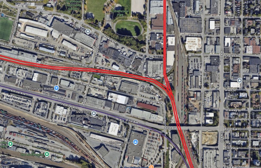
Continuing along North Grandview Highway, we would parallel the Expo Line for one km before heading north over East 1st Avenue. We would build another junction here; one line would go west to Pacific Central Station, while another would continue north. The connection to Pacific Central Station would not be used right away, but we should build the junction now, as it would be expensive to add on later.
Johnathan French/Google Maps
Johnathan French/Google Maps
Johnathan French/Google Maps
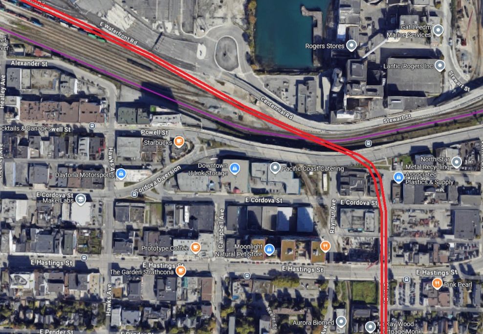
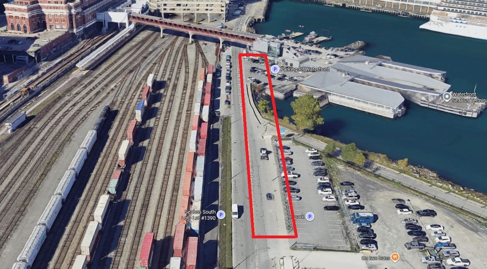
Continuing north via Glen Drive, once past Powell Street, we would fly over the freight tracks before heading west, parallel to Centennial Road and East Waterfront Road.
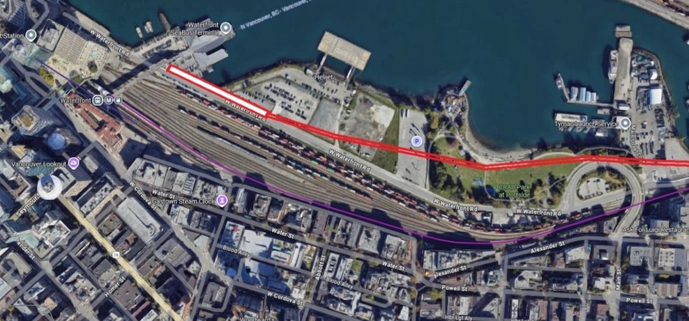
From there, the line could finally connect to Waterfront Station. We would construct one last elevated station right next to the SeaBus terminal on Waterfront Road.
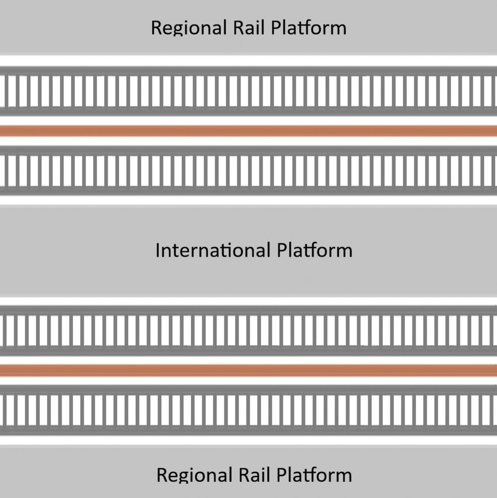
If we want to accommodate 200-metre-long trains, we need lots of space to work with, and the area by the SeaBus terminal is a good candidate. Because it is elevated like the other stations, this downtown Vancouver terminus station could be built at a relatively low cost. The alignment does not involve any tunnelling, nor any excessive expropriation. Passengers getting off here would still be able to transfer to the Expo Line or SeaBus without leaving the fare-paid zone, unlike those transferring from SkyTrain’s Canada Line.
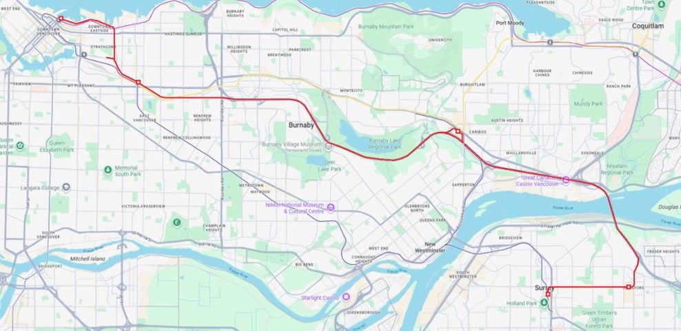
In total, this regional rail relief line project would require building five new stations, 14 km of elevated guideways, and 20 km of highway-running rail, for a total of 34 km. It would add a brand new, all-day rapid transit connection linking Waterfront, Commercial-Broadway, Lougheed Town Centre, Guildford Town Centre, and Surrey Central stations.
This would relieve congestion on the Expo Line, and future-proof regional connectivity.
Connections to Commercial-Broadway and Lougheed Town Centre stations would allow passengers from the Millennium Line to transfer to this new line instead of the Expo Line. Because the new line would be so much faster than the Expo Line, passengers near Surrey Central Station (like at King George and Gateway stations) would likely transfer to the new line to get to Vancouver; the same goes for future passengers travelling from Langley.
Johnathan French/Google Maps
Johnathan French/Google Maps
Johnathan French/Google Maps
Johnathan French/Google Maps
Johnathan French/Google Maps
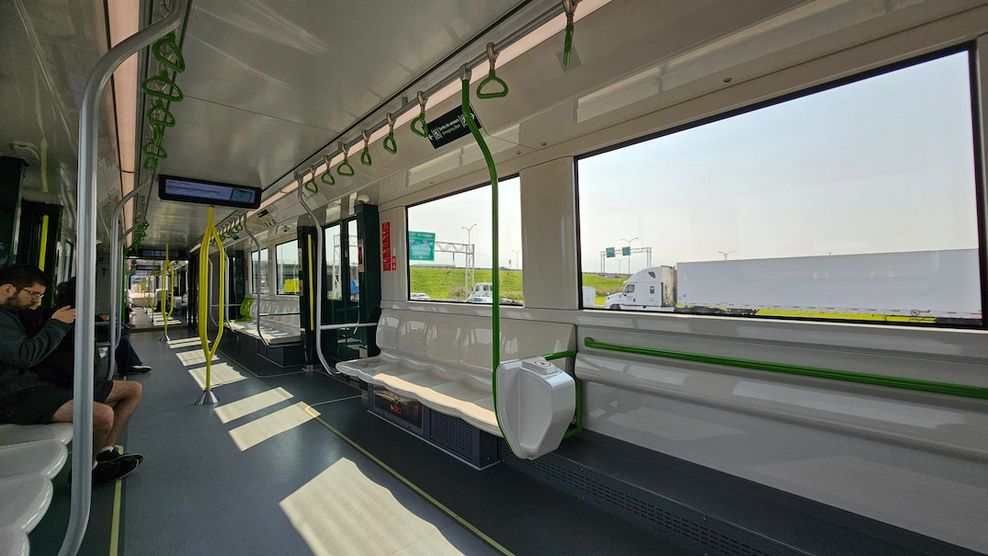
This project does not need to be overly expensive. You might think, looking at the Surrey-Langley SkyTrain extension — which will cost taxpayers $375 million per km — that a relief line would be similarly expensive, if not even more. However, that project for a 16-km-long Expo Line extension with eight new stations was massively inflated compared to other projects, jumping from $4 billion to $6 billion in 2024. A more comparable project to look at would be the REM (Réseau Express Métropolitain) in Montreal, which is a 67-km-long fully-automated light rail system. Once completed, REM is projected to cost $9.4 billion or $140 million per km.
Montreal’s REM has a lot of similarities to this Vancouver-Surrey relief line. They both re-use existing bridges (the REM uses the Champlain Bridge, which was built with extra space for rail rapid transit tracks) and highway medians, and require large elevated guideways. However, Vancouver’s first relief line project would be half the length of the REM, just 34 km, and would not involve any underground tunnelling. The REM project required significant tunnelling work, including the construction of a 72-metre-deep station, one of the deepest in the world — equivalent to 24 storeys below-grade. The REM also has 26 stations, whereas this project would only need five, all of which would be above-ground.
Even if we assume a similar cost-per-km (bearing in mind how much more complex the REM is), the entire 34-km-long Vancouver-Surrey relief line would cost just $4.7 billion dollars, based on present day costs.
Montreal’s new fully-automated REM metro line running down the centre median of a highway bridge. (Kenneth Chan)
REM in Montreal. (Kenneth Chan)
One might say that the REM’s low cost was only possible because of the in-house expertise of the Caisse — the Quebec pension fund previously known as the CDPQ, which is responsible for the REM and has a major stake in the public-private partnership for the Canada Line. I would argue that B.C. was able to achieve a similar cost-per-km with the Millennium Line’s Evergreen extension back in 2016. That 11-km-long project with six stations finished a bit late but under budget, at a cost of $1.4 billion or $127 million per km ($164 million per km when adjusted for inflation). That involved tunnelling two km deep underground, and squeezing the line in between an active railway and a busy street.
That said, if you believe this province is no longer competently able to build rail rapid transit projects efficiently and in a cost-effective manner, then we should hire Caisse and see what they propose.
Regional rail to the Fraser Valley along Highway 1
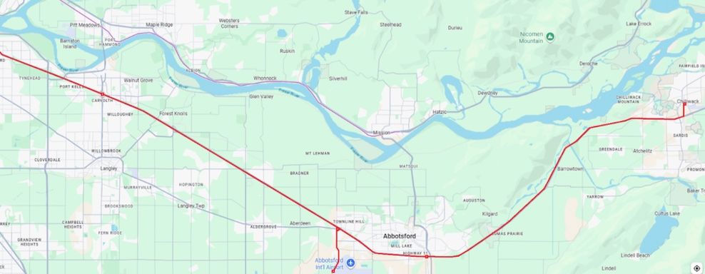
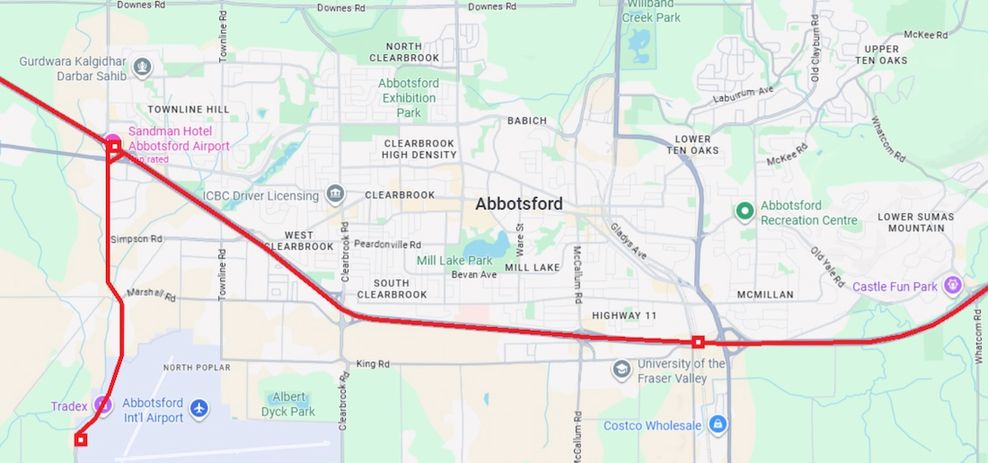
One way or another, we need a project like this to future-proof our transportation system. Once this initial system is built, future extensions will be much less expensive. For example, adding Abbotsford and Chilliwack to the system would mean building around 73 km of new rail, but this would all be in the median of Highway 1. We would not have to build any elevated guideways, bridges or tunnels (except maybe for a branch to Abbotsford International Airport), just some tracks and a few stations.
The fact that the provincial government is currently spending billions of taxpayer dollars widening Highway 1 through the Fraser Valley means that there is already sufficient demand to warrant regional rail. Abbotsford and Chilliwack combined have a population of over a quarter million residents; compare that to the population of Whitchurch-Stouffville in Ontario, population 50,000, which has had GO Train commuter rail service since the 1980s.
Let us look at what an extension to Chilliwack might look like. Again, keep in mind this is a hypothetical alignment meant to demonstrate feasibility.
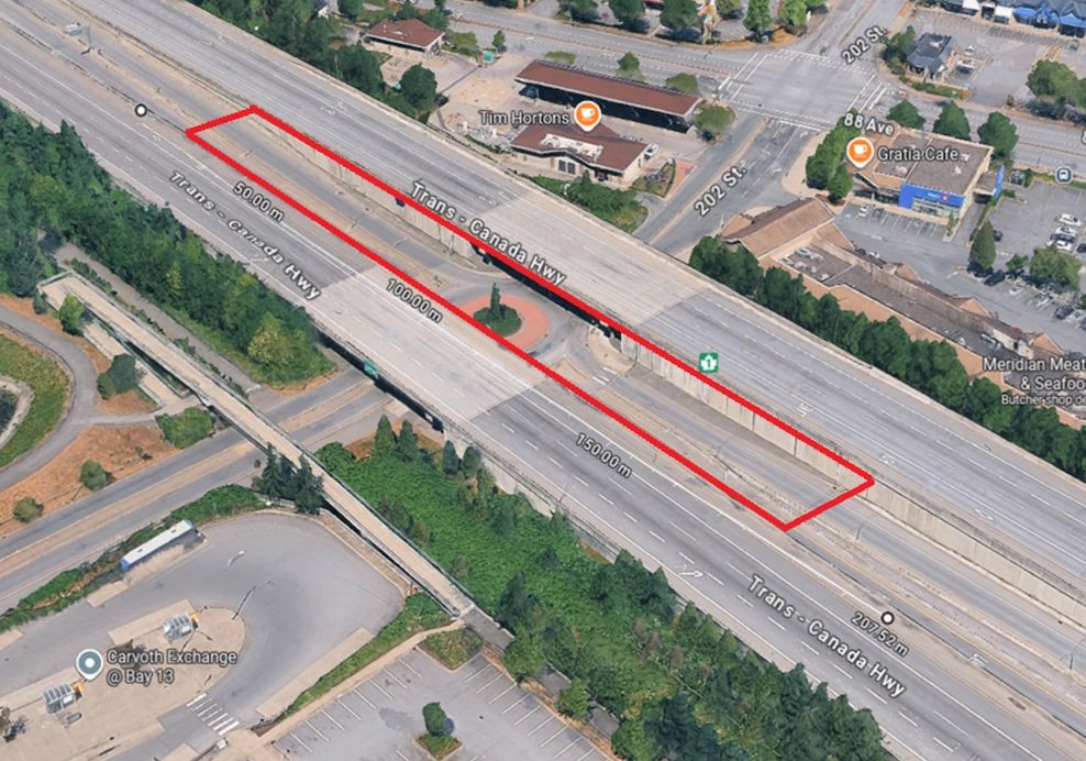
We would certainly want a station at Carvolth bus exchange to connect with the future Langley-Haney Place Bus Rapid Transit (BRT) line. There are already amenities in place for pedestrians and cyclists; an elevated station could sit right above the roundabout, allowing cars on and off the highway using the existing ramps.
Johnathan French/Google Maps
Johnathan French/Google Maps
Johnathan French/Google Maps
Johnathan French/Google Maps
Johnathan French/Google Maps
Johnathan French/Google Maps
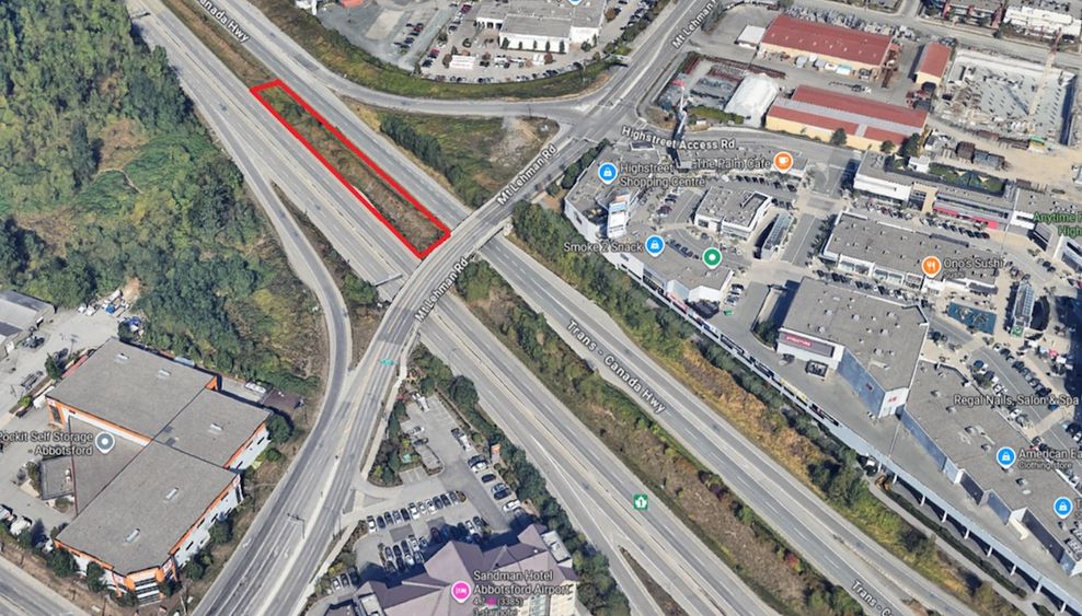
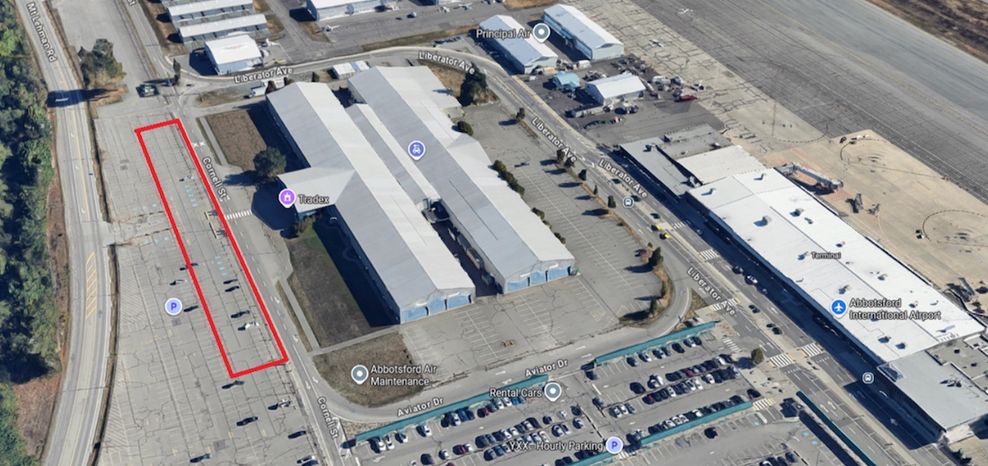
In Abbotsford, we could build a station under Mt. Lehman Road near the Highstreet Shopping Centre, with a short four-km-long branch down to Abbotsford’s airport. Passengers could connect to the station via Mt. Lehman Road, easily walking to nearby destinations like the mall or the Sandman Hotel.
The airport connection could operate as alternate terminus for trains coming from Surrey and Vancouver, allowing passengers to get to the airport without transferring. We could place the station right in front of the TRADEX Abbotsford Exhibition Centre, another key destination. It might seem excessive to build a dedicated airport rail link, but it is the only international airport in the area, one that could offer flights to everyone in the region. With a rail connection it could flourish and grow.
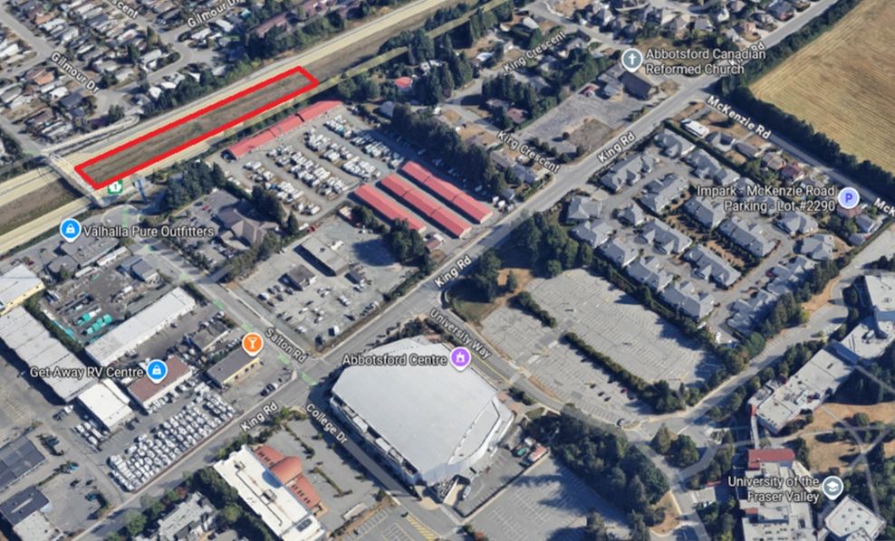
A second possible Abbotsford station could be at the bridge on Salton, near Abbotsford Centre and the University of the Fraser Valley campus. Connect these stations with feeder buses, and Abbotsford would be well-served.
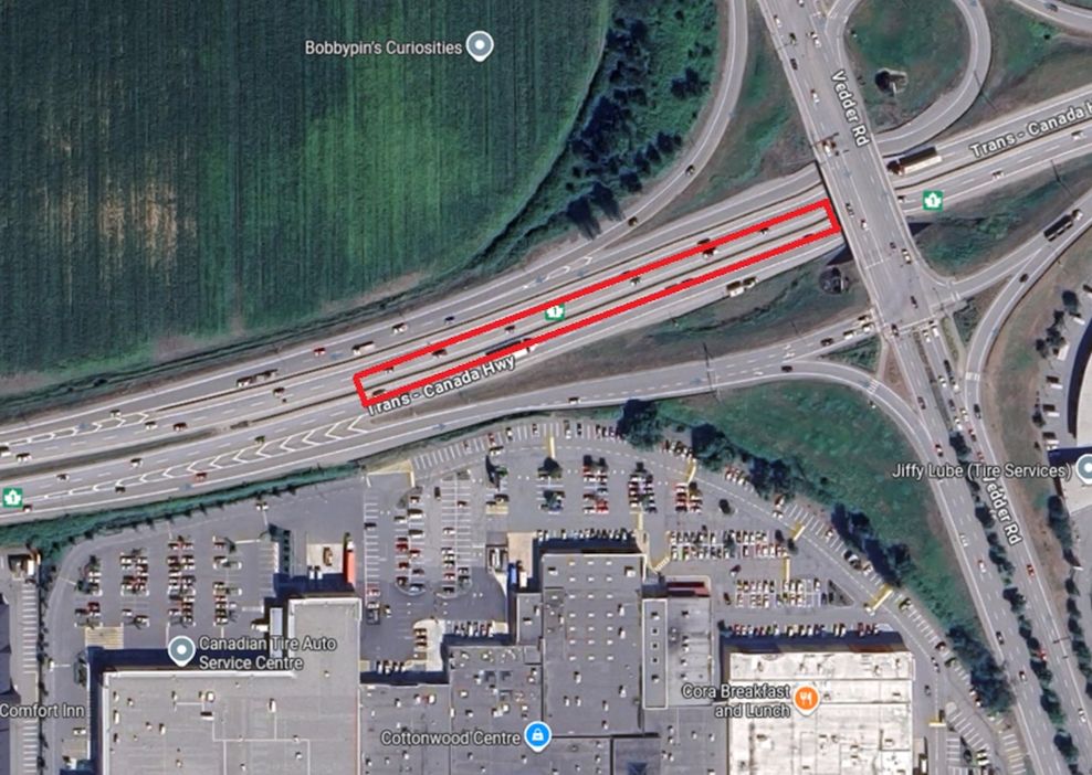
Finally, there is the terminus in Chilliwack. A station near Vedder Road makes sense, as this would keep costs low. Bus stops and stairs could easily be put in at the overpass, and we could also build a short pedestrian crossing on the south side to Cottonwood Centre.
This new line would fundamentally alter public transit in the Fraser Valley. Bus routes like TransLink’s No. 555 Carvolth Exchange/Lougheed Town Centre Station and BC Transit’s No. 66 Fraser Valley Express could be eliminated, and that extra capacity could be used to run feeder buses into the new train stations.
After 75 years, we would finally reconnect the Fraser Valley to Metro Vancouver with passenger rail.
Johnathan French/Google Maps
Johnathan French/Google Maps
Johnathan French/Google Maps
Johnathan French/Google Maps
Regional rail to South Surrey and White Rock
But we do not have to stop there. The line to Surrey Central could be extended to Newton Exchange, and White Rock.
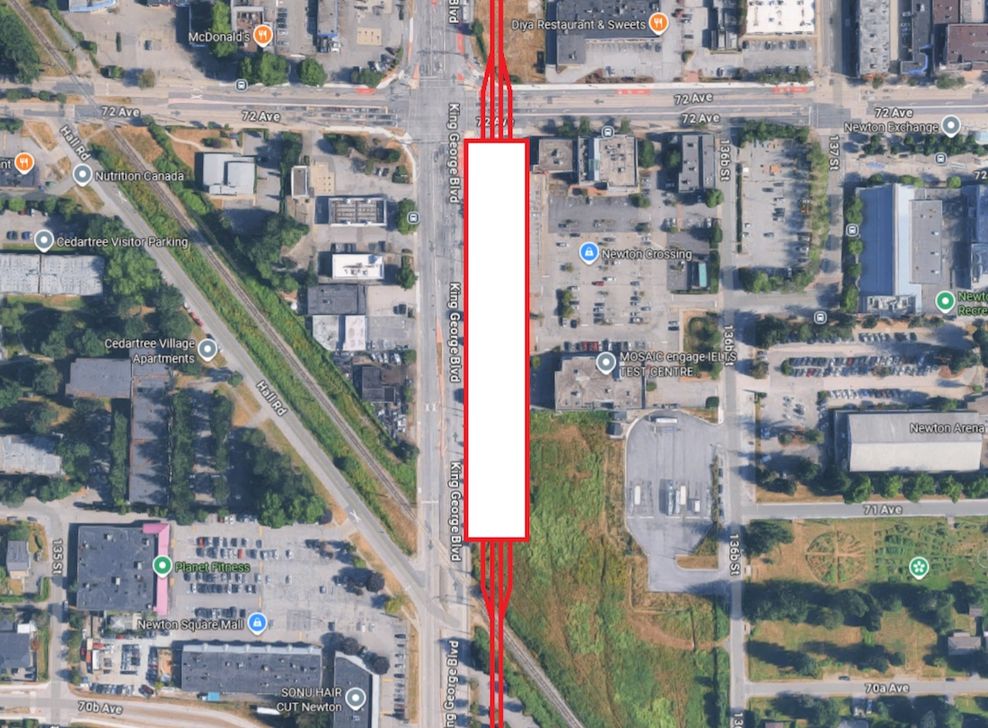
We would start by heading south from Surrey City Centre along King George Boulevard. We would need to construct approximately six km of elevated guideway to reach Newton bus exchange.
From here, we could replace the existing bus exchange with a larger one that directly connects to King George Boulevard, with a four-track train station above it. This stop would also allow for a future connection to Langley via the old interurban line, if we wanted.
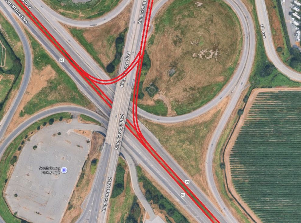
Continuing south, we would travel an additional 7.5 km along King George Boulevard before reaching Highway 99. At this position, we would transition to the highway median, and construct a junction to allow for a future extension west to Delta and Richmond along Highway 99.
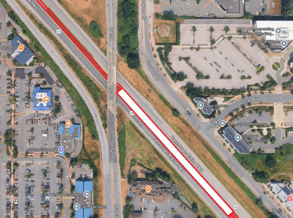
We would then travel south-east along Highway 99 for a little over two km, where we would build a station at 152nd Street.
This would be a four-track, ground-level station. There is plenty of room on either side to shift the highway lanes over, and it would be relatively simple to add pedestrian overpasses to connect to the nearby shopping centres and residences.
There is one caveat about using King George Boulevard, as it would probably make sense to retain the future King George Boulevard BRT or at least a RapidBus along this corridor. As this is a regional rail train, it is not meant to make stops at closely-spaced stations. There are still plenty of local destinations in between that would need to be served.
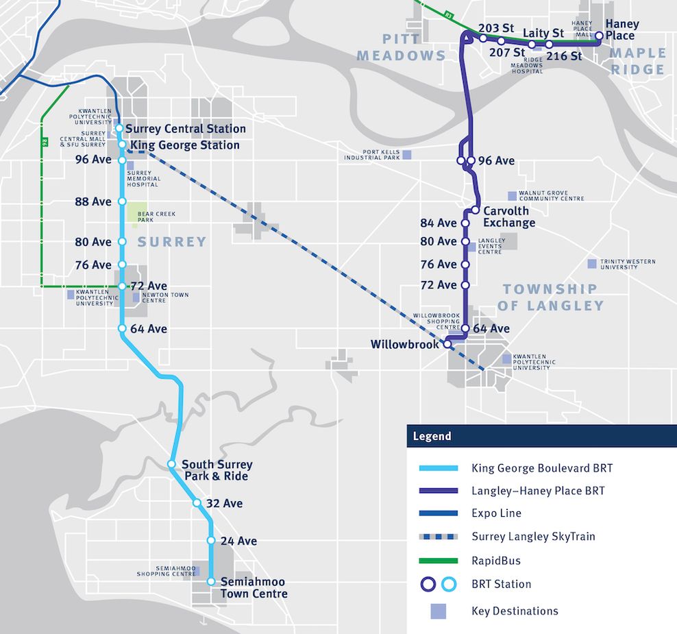
Proposed route map for King George Boulevard BRT and Langley-Haney Place BRT. (TransLink)
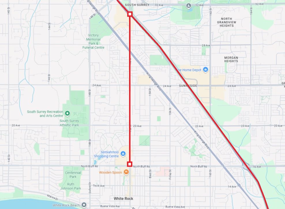
We should also include a junction at South Surrey to allow for a future extension to White Rock Centre. This would require a three-km-long elevated guideway along 152nd Street, and it would probably be worth it to support the area’s growing residential and commercial densification.
We would not prioritize the South Surrey/White Rock connection, at least not right away. That project requires at least eight km of elevated guideways and nine km rail in the median of Highway 99, plus rebuilding overpasses.
Of course, it is still a worthwhile project. The Newton area needs a rail connection, and South Surrey and White Rock’s population density definitely warrants one as well.
That said, if fully built out, this regional rail network would span over 125 km, connecting Chilliwack, White Rock, and Vancouver.
The initial segment to Surrey would provide much-needed relief to the SkyTrain system, especially the Expo Line. The extension out to Abbotsford and Chilliwack would bring passenger rail to the Fraser Valley again, with fast, frequent, all-day service, and an easy link to the Lower Mainland’s secondary international airport.
Travel times across the region would improve dramatically. For example, it is about 24 km between Abbotsford and Carvolth. Let us assume the trains can reach a top speed of 120 km/h. If acceleration takes about two minutes and covers about two km (and we assume the same for deceleration), this journey would take around 14 minutes.
It is a similar story with Lougheed Town Centre and Commercial-Broadway stations. This stretch is around 13.5 km; accounting for some slowdowns in the curvier parts of the highway, we could conceivably make this journey in just eight minutes, compared to the 19 minutes it takes today via the Millennium Line.
Regional rail trips between Waterfront and Surrey Central stations (adding a generous 60 seconds at every stop) could be done in under 25 minutes, compared to the 39 minutes it takes today via the Expo Line. Even accounting for transfers to and from Burrard Station or Granville Station, this new line would offer significant time savings.
Previous government files from the 2000s for the Port Mann Bridge project show that the modern crossing — with a wide bridge deck, the world’s widest at the time of opening — was designed specifically to accommodate a future light rail line, such as SkyTrain or REM. Heavy rail has vastly different load-bearing requirements, which raises the question of whether the Port Mann Bridge could be structurally enhanced to support heavy rail. If so, such an upgrade could not only enable regional heavy rail service but also provide a new crossing for Amtrak and VIA Rail trains.
Of course, if the Port Mann Bridge can be improved to handle heavy-rail passenger trains, then we should build the infrastructure from South Surrey to Vancouver with Amtrak trains in mind. That way, Amtrak trains could first stop at South Surrey, then continue non-stop to Pacific Central Station, a much more flexible arrangement for international passengers. This would also allow us to run heavy rail trains on the rest of the line, which would allow for much higher top speeds, potentially over 200 km/h in the Fraser Valley.
Johnathan French/Google Maps
Johnathan French/Google Maps
Johnathan French
We should also consider automating the system if the tracks are not shared with other passenger rail services. Automation has huge potential; it can not only reduce operating costs in the long run, but it can also dramatically improve frequency and therefore capacity.
We need to build something like this one way or another; this hypothetical alignment is just one potential option. People already avoid taking SkyTrain during peak periods due to chronic overcrowding.
Highway 1 and the Port Mann Bridge have huge potential. It is a giant stretch of asphalt with wide curves and plenty of space; it is a perfect candidate for regional rail.
SkyTrain is not the be-all-end-all for public transit. We need to think bigger, beyond our existing light metro system. Let us use Highway 1 and the Port Mann Bridge to build a relief line for the Expo Line, and use that as the backbone for regional rail in the Lower Mainland.
- You might also like:
- Cancelled 10-lane George Massey Bridge plan was designed to enable future new SkyTrain line
- How to better control the spiralling construction costs of Canada's public transit projects
- Montreal has opened a massive SkyTrain-inspired driverless train network (PHOTOS)
- 8-km-long Highway 1 widening in Abbotsford to cost $2.65 billion
- Opinion: TransLink and BC Transit should use the same digital fare payment system
- Opinion: Why this TransLink bus exchange in Surrey needs to be relocated
- Opinion: SkyTrain's future is at an uncertain crossroads after 40 years of success