
Opinion: SkyTrain's future is at an uncertain crossroads after 40 years of success

In the early 1980s, the Government of British Columbia made a choice that would later have a profound impact on how people in Metro Vancouver move and how the region is shaped and structured for growth.
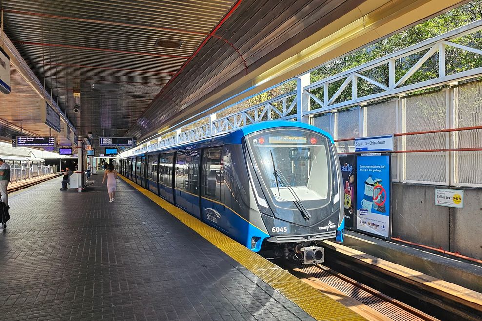
It chose to build the region’s first modern rail rapid transit line using the latest state-of-the-art innovations in fully automatic train control technology, as well as new Canadian-made linear induction motor (LIM) train propulsion technology.
LIMs on the underside of the SkyTrain vehicles used on the Expo and Millennium lines interact with a continuous aluminum strip down the centre of the tracks to create an electromagnetic reaction that propels the trains forward.
In contrast, the SkyTrain vehicles on the Canada Line use conventional electric motors — akin to most subways elsewhere in the world, like New York City, London, Hong Kong, Toronto, and many other systems. In some ways, the Canada Line trains have more similarities with a Tesla car than the trains on the Expo and Millennium lines, with an electric source powering onboard motors that push the train forward.
- You might also like:
- Opinion: Don't waste time and money on BRT or LRT, begin planning for North Shore-Metrotown SkyTrain
- Opinion: UBC SkyTrain must be Metro Vancouver's next public transit priority
- Opinion: SkyTrain expansion is unquestionably Metro Vancouver's way forward
- Opinion: If TransLink builds Bus Rapid Transit, it must be done right
- Opinion: Why the Hastings SkyTrain and North Shore SkyTrain lines should be built together
- 35 facts you might not know about SkyTrain
- 21 facts about SkyTrain's Millennium Line
LIMs are well-suited for the Expo and Millennium lines because they move trains using electromagnetic propulsion instead of relying on the grip of steel wheels. This means trains can accelerate quickly, climb steeper hills, and run reliably in rain, snow, or leaf-covered tracks. As well, this provides superior rapid acceleration and deceleration for a system with relatively closely spaced stations.
Aluminum electromagnetic strip in the centre of SkyTrain’s Millennium Line Evergreen extension tracks for linear induction motor (LIM) propulsion. (Bill Kingsland)
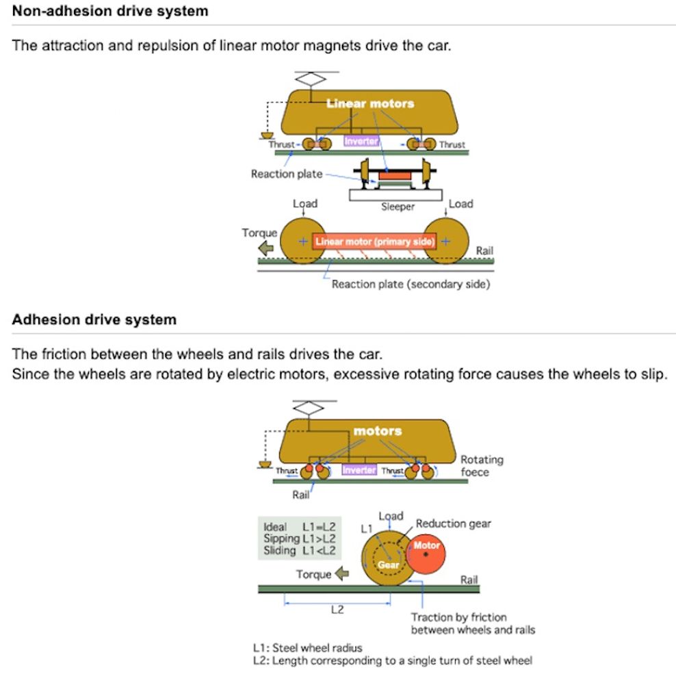
Diagram showing the differences between linear induction motors (non-adhesion drive system) and conventional rotary motors (adhesion drive system). (Kawasaki Heavy Industries)
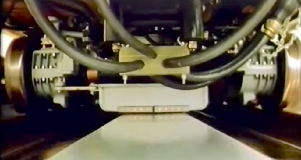
The narrow air gap between a SkyTrain car’s linear induction motors and the aluminum reaction plate on the tracks. (TransLink)
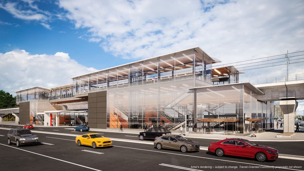
With fewer moving parts beneath the passenger floor than conventional motor technology, LIM-equipped trains generally have lower maintenance needs and can be built with a lower overall profile. This reduced underfloor height allows for smaller tunnels and slimmer elevated guideway structures, and works especially well with fully automated, high-frequency metro systems like SkyTrain. This was a key consideration for the Expo Line, which reused Canadian Pacific’s former freight tunnel — the tight Dunsmuir Tunnel, built in 1932 — for the downtown Vancouver segment between Stadium-Chinatown Station and Waterfront Station.
But no system is perfect; every advantage has its trade-offs.
The trains on the Expo and Millennium lines have a less-than-optimal narrow width compared with modern trains, which can reduce interior comfort and limit accessibility. This design constraint stems from the early legacy decision to size the Expo Line around the dimensions of the Dunsmuir Tunnel, a choice that continues to influence vehicle design today. By contrast, the Canada Line — built as a completely separate system — uses trains that are roughly half a metre wider, a difference that has a noticeable impact on interior space, comfort, and passenger flow.
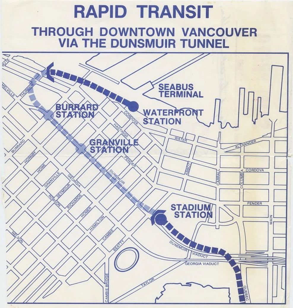
1982 planning map to repurpose Canadian Pacific’s former Dunsmuir Tunnel for SkyTrain’s Expo Line segment in downtown Vancouver. (TransLink)
Another downside is that LIMs on the Expo and Millennium lines can use more electricity than conventional motors and waste some energy as heat in the track, which can, on occasion, be seen from the track’s aluminum strip as rising steam during rainfall. LIMs also require extra equipment built into the guideway, which requires very precise measurements for installation, and adds to the initial capital and ongoing maintenance costs.
Trains on the Expo and Millennium lines also tend to emit more noise while in motion, particularly the high-pitched whine associated with the original Mark I fleet, which is now a model being retired and replaced by the new generation of Mark V trains. This sound does not come from wheel-and-rail contact, but from electromagnetic noise generated by the LIMs.
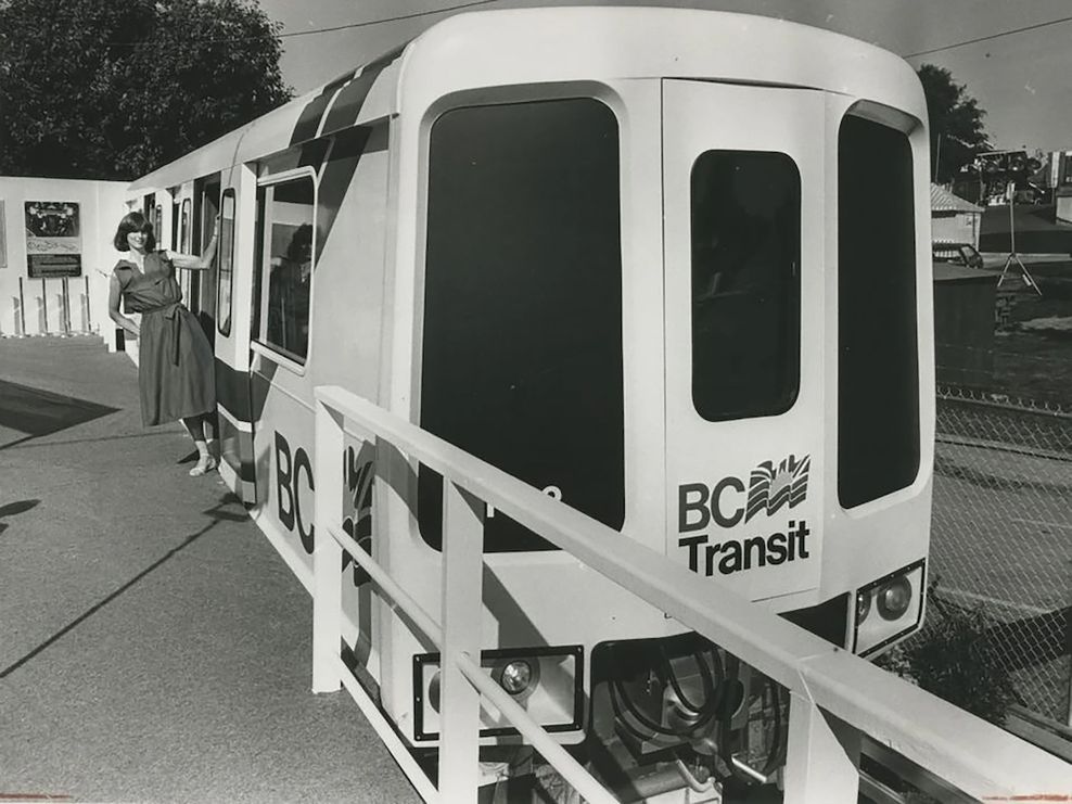
Prototype Mark I train during SkyTrain’s demonstration line period in 1982. (TransLink)
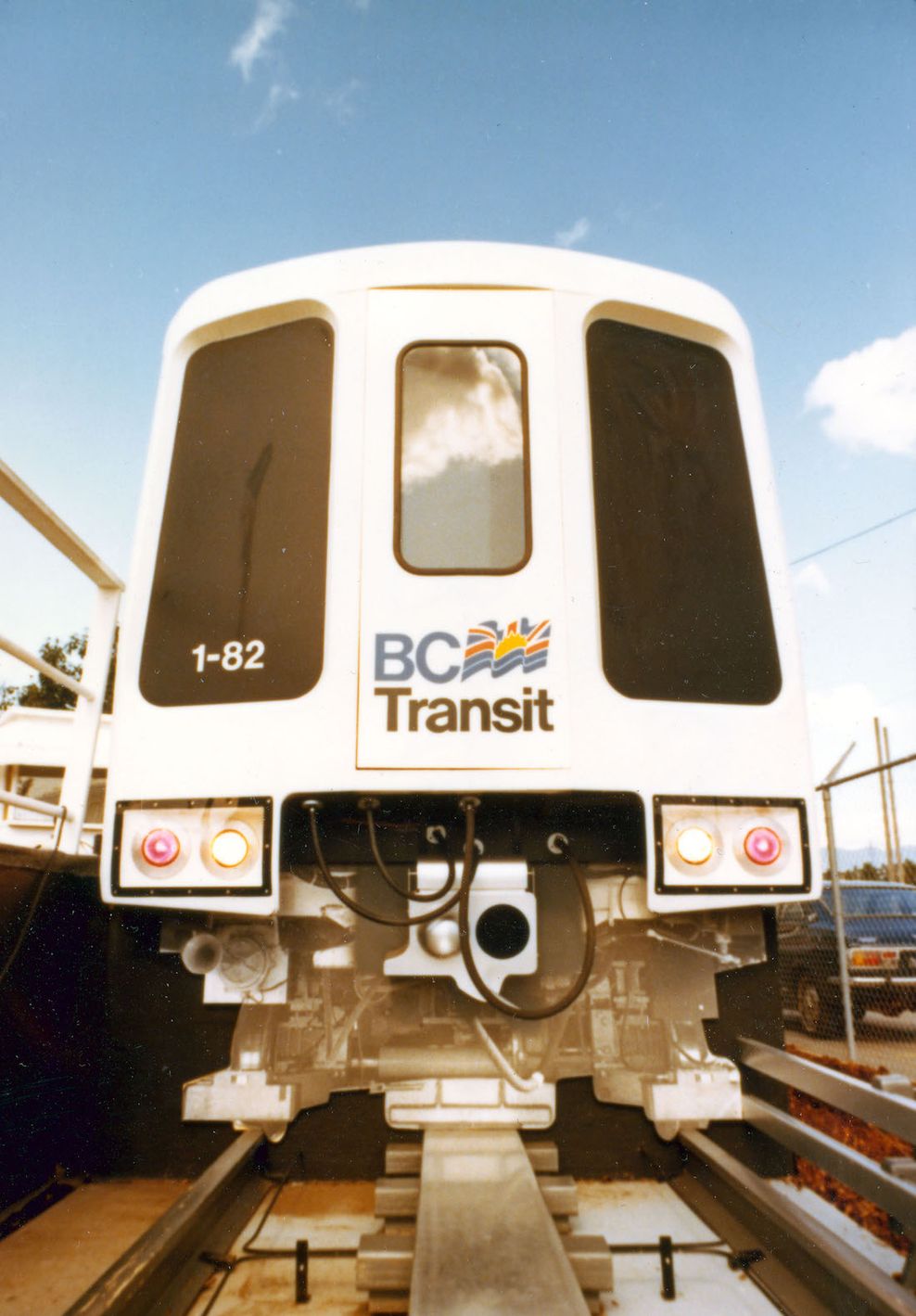
Prototype Mark I train during SkyTrain’s demonstration line period in 1982. (TransLink)

Prototype Mark I train during SkyTrain’s demonstration line period in 1982. (TransLink)
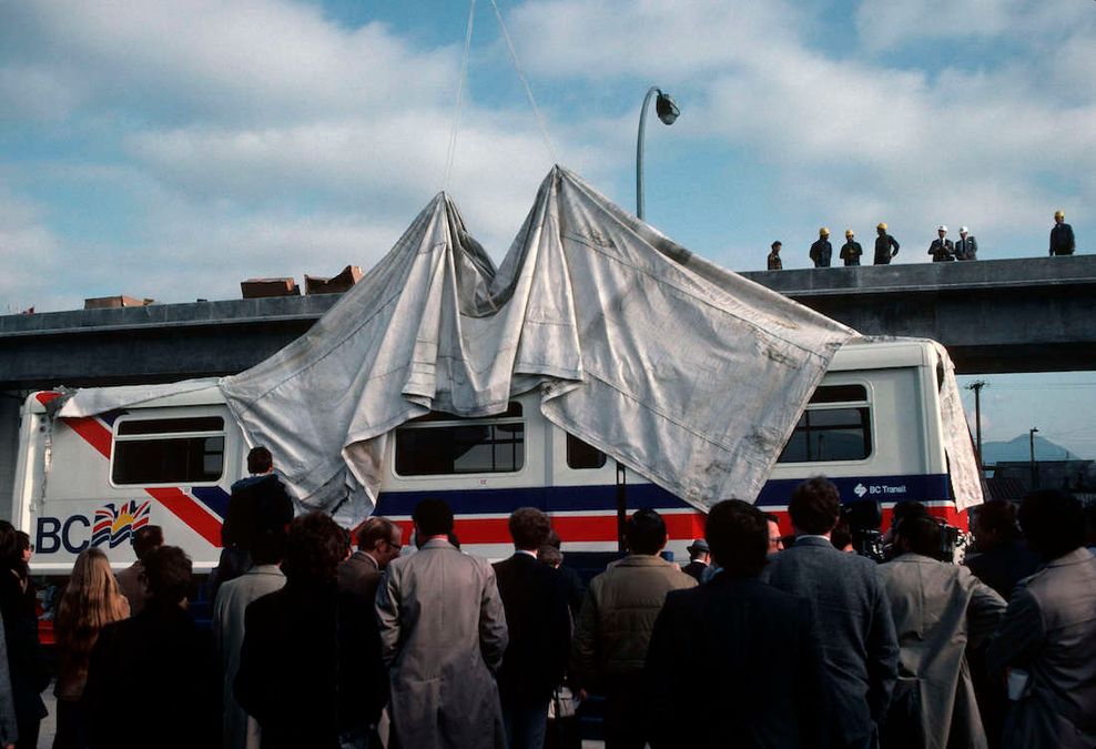
Unveiling of the first Mark I car for SkyTrain’s Expo Line in 1985. (TransLink)
At the time in the early 1980s, some wondered whether the then-futuristic technological combination of driverless trains and LIM applied for use on the scope of a metro rail network was a gamble — too ambitious, too expensive, and too unconventional.
But over the subsequent decades, both technologies, particularly full automation, have been increasingly adopted on other large systems elsewhere in the world, with Vancouver being an early pioneer.
SkyTrain punches above its weight
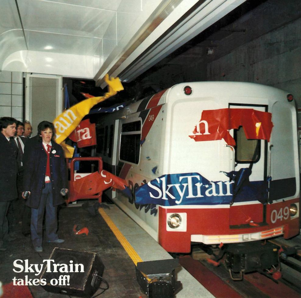
Last week, on Dec. 11, 2025, SkyTrain marked its 40th anniversary.
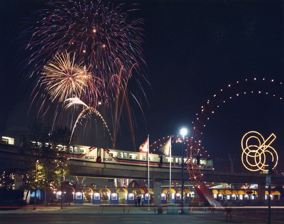
The Expo Line, Metro Vancouver’s first SkyTrain line, first opened in late 1985, just a few months before it began gliding above the crowds of the Expo ’86 World’s Fair in False Creek and below the Canada Pavilion (now known as Canada Place).
Built in time for the transportation-themed World’s Fair, the Expo Line originally opened as a route between Waterfront Station and New Westminster Station. It evolved from the initial one-km-long prototype demonstration line built in 1983, which ran along Terminal Avenue and included what is now Main Street–Science World Station.

SkyTrain’s Expo Line operating during the Expo ’86 World’s Fair. (TransLink)
SkyTrain’s Expo Line operating during the Expo ’86 World’s Fair. (TransLink)
In fact, for roughly 12 years — from the start of construction on the demonstration line in 1982 to the Expo Line’s phased extension reaching Whalley (what is known as Surrey City Centre today) in 1994 — the region experienced almost continuous major construction activity for SkyTrain. Over that entire period, the Expo Line expanded steadily with back-to-back-to-back-to-back-to-back major construction work, bringing SkyTrain to Columbia Station in 1989, across the Fraser River to Scott Road Station in 1991, and finally King George Station in 1994.
Over the first 17 years of the Expo Line’s operations, the line was simply known as “SkyTrain” as it was the only line. It did not gain the Expo Line name until 2002, when the Millennium Line opened.
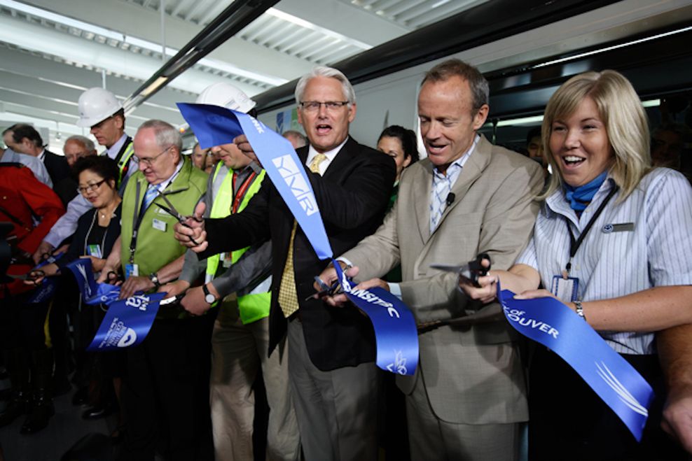
Then, of course, the Canada Line opened in 2009, just months before the 2010 Winter Olympics. Contrary to some popular belief, the Canada Line is indeed a “SkyTrain line,” branded as such by TransLink and fully integrated into Metro Vancouver’s SkyTrain rapid transit network.
December 1985 opening of SkyTrain’s Expo Line at Waterfront Station. (TransLink)

January 2002 opening of SkyTrain’s Millennium Line at Lougheed Town Centre Station. (TransLink)
August 2009 opening of SkyTrain’s Canada Line at YVR Airport Station. (TransLink)
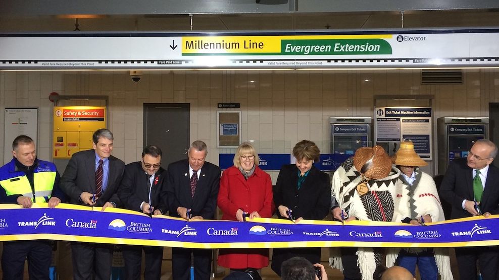
December 2016 opening of SkyTrain’s Millennium Line Evergreen extension at Coquitlam Central Station. (TransLink)
Although TransLink contracts out the Canada Line’s operations and maintenance to a private company — a contract that expires in 2041 — and the line uses conventional motor technology rather than LIMs, the characteristics that truly define SkyTrain are full automation and full grade separation, qualities that sharply distinguish it from street-level light rail transit (LRT).
Full grade separation combined with full automation has enabled the Expo, Millennium, and Canada lines to achieve high operating speeds and competitive travel times compared with driving, while also supporting very high service frequencies. This removes much of the guesswork and schedule planning for riders, as trains do not depend on the availability of onboard drivers, unlike conventionally operated systems. As a result, improved service levels can be delivered at relatively lower operating costs, with some labour requirements taken out of the equation.
The use of driverless trains also enables high capacity through shorter trains running more frequently, rather than relying on longer, human-driven trains that arrive less often. For example, a two-car automated train every three minutes can provide similar overall capacity to a six-car operator-driven train every nine minutes, while offering shorter waits and a more convenient, “turn up and go” service experience.
Furthermore, SkyTrain provides greatly enhanced reliability, with human error taken out of the equation in terms of both not having drivers run the trains and not having to share any of its track space with any vehicle traffic.
SkyTrain’s speed, frequency, and reliability have helped TransLink achieve one of the highest per-capita ridership levels in Canada, surpassing Greater Toronto and Hamilton areas and closely trailing Greater Montreal.
Unveiling of SkyTrain’s first new Mark V train on July 10, 2025. (Kenneth Chan)
These strengths also supported Metro Vancouver’s strong public transit ridership recovery coming out of the pandemic, enabling SkyTrain to consistently punch well above its weight — given the region’s size, population, economic capacity, as well as the size of the SkyTrain network itself — when compared with much larger major urban centres in Canada and the United States.
Based on data from the American Public Transportation Association, the following is a rundown of average weekday ridership on heavy rail subway and LRT networks across major Canadian and American public transit systems in the third quarter of 2025, ranked by combined total rail rapid transit ridership:
- New York City:
- NYC MTA subway heavy rail: 7,353,000 per weekday
- Number of stations: 423
- Average ridership per station per weekday: 17,380
- Length: 399 km
- Average ridership per km per weekday: 18,430
- NYC/NJ PATH subway heavy rail: 216,000 per weekday
- Number of stations: 13
- Average ridership per station per weekday: 16,620
- Length: 22 km
- Average ridership per km per weekday: 9,820
- NYC metropolitan population: 20.1 million residents
- NYC MTA subway heavy rail: 7,353,000 per weekday
- Toronto:
- TTC subway heavy rail: 1,079,000 per weekday
- Number of stations: 87
- Average ridership per station per weekday: 12,400
- Length: 80 km
- Average ridership per km per weekday: 13,490
- Metropolitan population: 7.67 million residents
- TTC subway heavy rail: 1,079,000 per weekday
- Montreal:
- Metro subway rubber-tired: 946,000 per weekday
- Number of stations: 68
- Average ridership per station per weekday: 13,910
- Length: 69 km
- Average ridership per km per weekday: 13,710
- Metropolitan population: 4.62 million residents
- Metro subway rubber-tired: 946,000 per weekday
- Washington, D.C.:
- Metro subway heavy rail: 461,000 per weekday
- Number of stations: 98
- Average ridership per station per weekday: 4,700
- Length: 208 km
- Average ridership per km per weekday: 2,220
- Metropolitan population: 6.3 million
- Metro subway heavy rail: 461,000 per weekday
- Vancouver:
- SkyTrain: 456,000 per weekday
- Number of stations: 54
- Average ridership per station per weekday: 8,440
- Length: 80 km
- Average ridership per km per weekday: 5,700
- Metropolitan population: 3.05 million residents
- SkyTrain: 456,000 per weekday
- Chicago:
- “L” heavy rail: 454,000 per weekday
- Number of stations: 146
- Average ridership per station per weekday: 3,110
- Length: 165 km
- Average ridership per km per weekday: 2,750
- Metropolitan population: 9.41 million residents
- “L” heavy rail: 454,000 per weekday
- Boston:
- Subway heavy rail: 328,000 per weekday
- Number of stations: 54
- Average ridership per station per weekday: 6,070
- Length: 64 km
- Average ridership per km per weekday: 5,125
- LRT: 120,000 per weekday
- Number of stations: 78
- Average ridership per station per weekday: 154
- Length: 47 km
- Average ridership per km per weekday: 2,560
- Metropolitan population: 4.94 million residents
- Subway heavy rail: 328,000 per weekday
- San Francisco:
- BART subway heavy rail: 174,000 per weekday
- Number of stations: 50
- Average ridership per station per weekday: 3,500
- Length: 212 km
- Average ridership per km per weekday: 820
- MUNI Metro LRT: 105,000 per weekday
- Number of stations: 117
- Average ridership per station per weekday: 900
- Length: 63 km
- Average ridership per km per weekday: 1,670
- Metropolitan population: 9.65 million residents
- BART subway heavy rail: 174,000 per weekday
- Calgary:
- LRT: 249,000 per weekday
- Number of stations: 45
- Average ridership per station per weekday: 5,530
- Length: 60 km
- Average ridership per km per weekday: 4,150
- Metropolitan population: 1.57 million residents
- LRT: 249,000 per weekday
- Los Angeles:
- Metro subway heavy rail: 61,000 per weekday
- Number of stations: 22
- Average ridership per station per weekday: 2,770
- Length: 32 km
- Average ridership per km per weekday: 1,900
- LRT: 142,000 per weekday
- Number of stations: 102
- Average ridership per station per weekday: 1,390
- Length: 175 km
- Average ridership per km per weekday: 810
- Metropolitan population: 13 million residents
- Metro subway heavy rail: 61,000 per weekday
- Seattle:
- Link LRT: 126,000 per weekday
- Number of stations: 48
- Average ridership per station per weekday: 2,630
- Length: 88 km
- Average ridership per km per weekday: 1,430
- Metropolitan population: 4.15 million residents
- Link LRT: 126,000 per weekday
- San Diego:
- LRT: 124,000 per weekday
- Number of stations: 62
- Average ridership per station per weekday: 2,000
- Length: 105 km
- Average ridership per km per weekday: 1,180
- Metropolitan population: 3.3 million residents
- LRT: 124,000 per weekday
- Atlanta:
- Metro subway heavy rail: 99,000 per weekday
- Number of stations: 38
- Average ridership per station per weekday: 2,600
- Length: 77 km
- Average ridership per km per weekday: 1,290
- Metropolitan population: 6.41 million residents
- Metro subway heavy rail: 99,000 per weekday
- Edmonton:
- LRT: 96,000 per weekday
- Number of stations: 29
- Average ridership per station per weekday: 3,300
- Length: 37 km
- Average ridership per km per weekday: 2,590
- Metropolitan population: 1.42 million residents
- LRT: 96,000 per weekday
- Ottawa:
- O-Train LRT: 72,000 per weekday
- Number of stations: 25
- Average ridership per station per weekday: 2,880
- Length: 36 km
- Average ridership per km per weekday: 2,000
- Metropolitan population: 1.5 million residents
- O-Train LRT: 72,000 per weekday
- Portland:
- MAX LRT: 66,000 per weekday
- Number of stations: 93
- Average ridership per station per weekday: 710
- Length: 96 km
- Average ridership per km per weekday: 690
- Metropolitan population: 2.51 million residents
- MAX LRT: 66,000 per weekday
- Dallas:
- DART LRT: 64,000 per weekday
- Number of stations: 73
- Average ridership per station per weekday: 880
- Length: 192
- Average ridership per km per weekday: 330
- Metropolitan population: 7.64 million residents
- DART LRT: 64,000 per weekday
- Houston:
- METRORail LRT: 42,000 per weekday
- Number of stations: 39
- Average ridership per station per weekday: 1,080
- Length: 37 km
- Average ridership per km per weekday: 1,140
- Metropolitan population: 7.12 million residents
- METRORail LRT: 42,000 per weekday
- Salt Lake City:
- TRAX LRT: 39,000 per weekday
- Number of stations: 52
- Average ridership per station per weekday: 750
- Length: 72 km
- Average ridership per km per weekday: 540
- Metropolitan population: 1.26 million residents
- TRAX LRT: 39,000 per weekday
Metro Vancouver’s SkyTrain ranks as the fifth busiest rail rapid transit system in Canada and the U.S. — coming narrowly behind Washington, D.C., and just ahead of Chicago and Boston. Notably, it is also the only fully automated metro system among these peer cities.
Despite serving a much smaller metropolitan population, SkyTrain compares extremely well with larger rapid transit systems across both Canada and the United States. With 456,000 average weekday riders across 80 km and 54 stations, SkyTrain achieves roughly 8,440 riders per station per weekday and, more importantly, 5,700 riders per km per weekday. These figures place it well ahead of most North American heavy rail metros and LRT systems, many of which operate in significantly larger urban regions.
SkyTrain’s ability to nearly match or outperform much bigger networks on a per-km basis underscores how effectively it is used relative to its size. This reflects a combination of full grade separation, high frequencies, competitive travel times, and strong integration with regional land use — factors that continue to set SkyTrain apart from most North American rail networks.
August 2009 opening day lines at Waterfront Station for SkyTrain’s Canada Line. (TransLink)

August 2009 opening day lines at Broadway-City Hall Station for SkyTrain’s Canada Line. (TransLink)
Expanding SkyTrain is the right decision
As SkyTrain marks its 40th anniversary, the verdict is unmistakable: SkyTrain was not just the right decision — it was a visionary one that continues to pay dividends every day.
Its record shows why public transit services, completely unconstrained by vehicle traffic, have been essential to building the Metro Vancouver we know today.
Theoretical street-level LRT alternatives — running in vehicle traffic, stopping at lights, limited in speed and frequency — could never have attracted or sustained this level of ridership, nor reshaped development around stations in the way SkyTrain has. Elsewhere in the continent, cities that committed to street-level LRT‐first networks often struggle with much slower and uncompetitive travel times, poorer reliability, lower frequencies, much lower ridership, and higher long-term operating costs.
When it comes to catalyzing transit-oriented development (TOD), LRT, by contrast, tends to anchor lower-density, mid-rise corridors.
The optimal real-world functionality offered by fully grade-separated SkyTrain catalyzed real urban centres and hubs — it further entrenched downtown Vancouver’s place in the region, and fuelled Metrotown, Brentwood Town Centre, Lougheed Town Centre, Burquitlam, Coquitlam City Centre, Surrey City Centre, Richmond City Centre, Oakridge Town Centre, Marine Gateway, and downtown New Westminster — and this was long before it became local planning orthodoxy. The Central Broadway corridor is next, in its evolution as Vancouver’s second city centre under the Broadway Plan.
July 2024 view of high-rise towers near SkyTrain’s Lougheed Town Centre Station and Burquitlam Station. (Kenneth Chan)
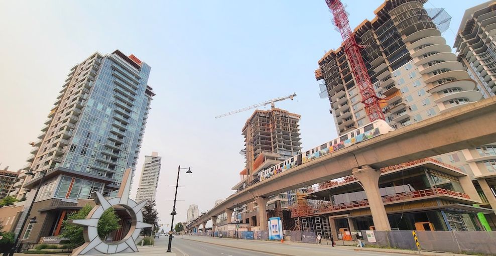
August 2023 view of high-rise towers under construction near SkyTrain’s Burquitlam Station. (Kenneth Chan/Daily Hive)
Simply put, full grade-separation means a higher degree of transportation reliability, and such reliability, paired with high capacity — guided by land use policy — attracts density. This includes organic economic and development growth that goes far beyond what was originally contemplated in land use policies.
Metro Vancouver’s TOD leadership in North America owes as much to that SkyTrain vision as to any planning document.
A forthcoming misadventure into permanent Bus Rapid Transit?
Yet there have been four notable junctures when street-level LRT was seriously considered in Metro Vancouver for a primary regional arterial corridor.
These included the mid-1990s planning for the original Millennium Line, which ultimately became the region’s second SkyTrain line; calls from project critics and skeptics in the early 2000s to pursue improved bus service or street-level LRT in an effort to reduce construction costs for the Canada Line, which ultimately opened as a fully grade-separated, driverless rapid transit line, the region’s third SkyTrain line; planning throughout the latter half of the 2000s for an Evergreen Line LRT, which ultimately became the seamless Evergreen extension of SkyTrain’s Millennium Line; and extensive planning during much of the 2010s for the Surrey Newton-Guildford LRT, which was ultimately cancelled in favour of extending SkyTrain’s Expo Line seamlessly to Langley City Centre.
At each juncture, explorations of LRT — sometimes lasting for half a decade or more — ultimately pivoted right back to SkyTrain, as it consistently offered superior long-term cost-benefit outcomes, significantly higher ridership potential, and a stronger ability to attract new public transit riders.
Metro Vancouver’s new focus on Bus Rapid Transit (BRT) for major regional arterial corridors risks repeating the same pattern seen in earlier debates over LRT — emphasizing expediency and lower upfront capital costs. This also risks replicating many of the same mistakes made by other Canadian and American public transit systems — mistakes that have been avoided by Metro Vancouver’s public transit authority, up until now.
BRT and LRT can be effective long-term permanent — if not at least semi-permanent — solutions in corridors of lower or secondary regional importance. TransLink’s serious proposal, currently under planning, to build the Langley–Haney Place BRT project (linking Langley City Centre and Haney Place via 200 Street) is the right move for this reason.
Other lower or secondary corridors where potential BRT projects have been identified by TransLink and its Mayors’ Council — and could be the suitable rapid transit solution for the corridor — include the Lougheed Highway corridor between Coquitlam Central Station and Haney Place (a major upgrade of the R3 RapidBus), the Scott Road–72 Avenue corridor between Scott Road Station and Newton Exchange (a major upgrade of the R6 RapidBus), the Richmond Centre-Metrotown corridor via the Knight Street Bridge, the Marine Drive Station-22nd Avenue Station corridor via Marine Drive and Marine Way, and the Lynn Valley-Downtown Vancouver/Lonsdale corridor via the Lions Gate Bridge.
In addition to Langley-Haney Place BRT, major planning and design work is now also well underway for BRT on two regionally significant primary arterial routes — the King George Boulevard BRT project between Surrey Central Station and White Rock Town Centre, and the Metrotown-North Shore BRT project between Metrotown Station and Park Royal via Willingdon Avenue, Hastings Street, and the Ironworkers Memorial Bridge (an upgrade of the R2 RapidBus).
Over the longer term, under TransLink’s strategy, BRT is also an envisioned possibility for the very important Hastings Street corridor between downtown Vancouver and Burnaby as an upgrade of the R5 RapidBus, although this route has not yet entered detailed planning and is not among the three currently prioritized for implementation.
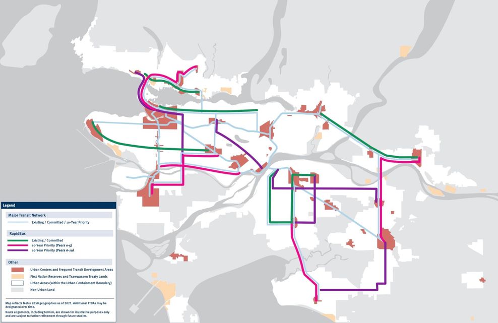
First 10-year plan of new BRT corridors, Transport 2050. (TransLink)
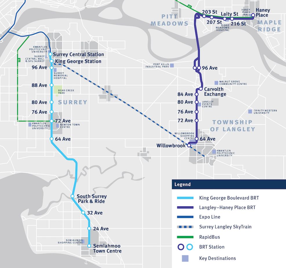
2025 proposed route map for King George Boulevard BRT and Langley-Haney Place BRT. (TransLink)
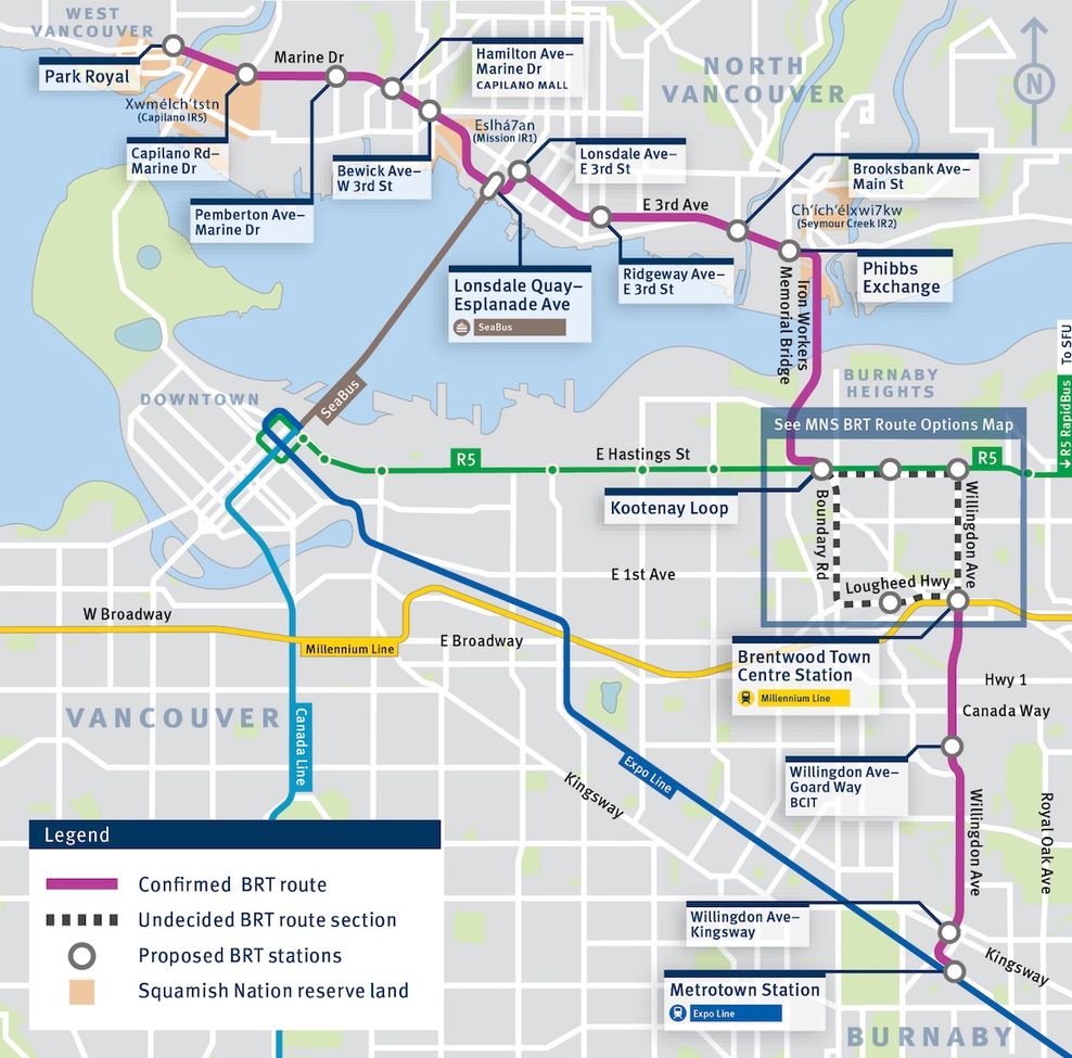
Option 1 and Option 2; proposed routes for Metrotown-North Shore BRT, 2025. (TransLink)
BRT has a promise and a place in Metro Vancouver — the region is in need of a multi-mode/layered bus network beyond merely local bus routes — but that place is arguably solely on lower- and secondary-importance corridors. BRT does not belong on regionally significant routes where long-term capacity, speed, ridership demand, and economic considerations require a far more robust rapid transit solution: the extension of the SkyTrain network on the three corridors of King George Boulevard, Metrotown-North Shore, and Hastings Street.
Joining the Expo Line, Millennium Line, Canada Line, and the current construction projects of SkyTrain’s Broadway and Surrey-Langley extensions, these three important corridors must be part of Metro Vancouver’s backbone arterial rapid transit network of SkyTrain.
SkyTrain for King George Boulevard, Metrotown-North Shore, and Hastings corridors instead of BRT
Rather than pursuing BRT along King George Boulevard, a SkyTrain extension of the Expo Line is needed from the outset between Surrey Central Station and at least 72 Avenue in Newton, with the remaining segment between Newton and White Rock Town Centre served by a shorter BRT line. The scale, growth trajectory, and regional importance of Surrey City Centre warrant a north-south SkyTrain corridor through Surrey, providing the long-term capacity and speed needed to support its continued economic development. Such an extension would also have a transformative impact on Surrey’s bus network, enabling crosstown and east–west local routes to feed directly into SkyTrain stations and significantly improving overall network connectivity.
Instead of pursuing BRT on the Metrotown-North Shore corridor, a new SkyTrain line is needed along this route. Such a line would provide a truly competitive east-west rapid transportation alternative on the North Shore between Park Royal and Phibbs Exchange, while also creating an additional Burrard Inlet crossing — ultimately reaching Metrotown Station. It would serve the dual purpose of establishing a high-capacity north-south spine through Burnaby, with the ability to transfer to the Millennium Line at Brentwood Town Centre Station and the Expo Line at Metrotown Station.
This would be transformative not only for the North Shore but for the existing SkyTrain network as a whole, creating a much-needed mid-point route and eliminating today’s indirect travel patterns that force riders to loop around the outer ends of the Expo and Millennium lines.
A preliminary study in 2023 commissioned by the District of North Vancouver found a 19.5-km-long Metrotown-North Shore SkyTrain line with 10 stations could see a very high ridership of 120,000 passengers per day, made possible by end-to-end travel times of just 23 minutes between Park Royal and Metrotown Station.
Achieving SkyTrain on the Metrotown-North Shore corridor is also crucial if the Lynn Valley-Downtown Vancouver/Lonsdale corridor via the Lions Gate Bridge is to be served by BRT. If the Metrotown-North Shore corridor is instead limited to BRT, then SkyTrain investment should instead be prioritized for the Lynn Valley-Downtown Vancouver/Lonsdale corridor via the First Narrows/Stanley Park. The North Shore needs to be connected to the rest of the region by at least one SkyTrain line.
A new SkyTrain line along Hastings Street, extending from downtown Vancouver to at least the Burnaby Heights and Capitol Hill neighbourhoods, would unlock the corridor’s immense potential for densification and support the eastward expansion of the city centre. It would also elevate the role of Hastings Park and the PNE’s major spectator facilities for sports and entertainment — including the new amphitheatre and the potential new Vancouver Whitecaps FC soccer stadium and mixed-use entertainment district — into a truly regional destination. Moreover, such a line would provide a second high-capacity, east-west rapid transit route into downtown Vancouver, serving as a critical relief line for the Expo Line, which is expected to approach capacity over the coming decades.
A Hastings SkyTrain line could potentially even function as an offshoot of the Metrotown-North Shore SkyTrain line, together operating similarly to the Canada Line’s offshoots into the airport and Richmond City Centre and forming a network spine analogous to Toronto’s Ontario Line. Like the Ontario Line, this combined corridor would create new direct transportation routes, relieve pressure on existing lines, and reshape regional travel patterns.
Over the longer term, and under a phased approach, there is also potential for a westward extension of the Hastings SkyTrain line to serve the West End and Coal Harbour neighbourhoods, Stanley Park, and potentially the North Shore as an additional rapid transit crossing, given the very obvious capacity and reliability deficiencies of the Lions Gate Bridge.
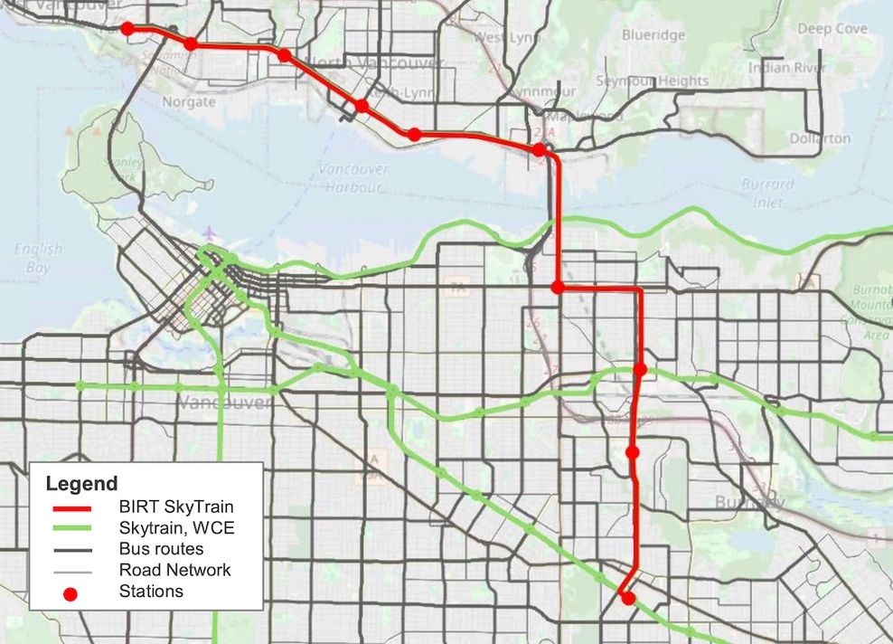
2023 SkyTrain concept for the Burrard Inlet Rapid Transit Line. (McElhanney/District of North Vancouver)

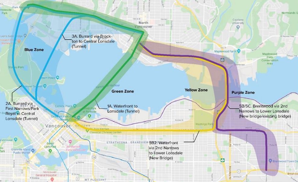
2021 Burrard Inlet Rapid Transit concept options of two North Shore SkyTrain lines via the Second Narrows: Gold Line from Park Royal to downtown Vancouver via Hastings, and Purple Line from Park Royal to Brentwood Town Centre Station and Metrotown Station via Willingdon Avenue. (North Shore Connects)
September 2020 map of North Shore SkyTrain route options. (Government of BC)
There is no question that the King George Boulevard SkyTrain extension, Metrotown-North Shore SkyTrain line, and Hastings SkyTrain line are highly ambitious, expensive, and complex propositions. The Metrotown-North Shore rapid transit solution also needs to consider the eventual replacement of the aging Ironworkers Memorial Bridge, with a new crossing potentially offering both vehicle lanes and space for rail rapid transit.
For a rapidly growing major urban region that is among the densest and most geographically compact and constrained in North America — and one that deliberately chose not to build a comprehensive freeway system more than half a century ago and lacks extensive arterial roads — the focus must be on quality over quantity. Compounding this reality is the absence of a true regional commuter rail network: with extremely limited West Coast Express service and coverage far short of systems like Greater Toronto’s GO Transit or Greater Montreal’s Exo, existing and future SkyTrain lines must serve the dual role of both urban rapid transit and de facto commuter rail.
Yet despite these constraints and shortcomings, the region is now considering rapid transit infrastructure that falls short of what its unique geography, density, and long-term needs truly demand.
Build BRT on secondary corridors of importance, and begin SkyTrain planning on primary corridors now
Potentially spending nearly $1 billion — or more — on the three proposed BRT lines, based on preliminary cost estimates of $250 million to $300 million per corridor, is no small sum. This is especially concerning when two of these lines would under-serve primary regional arterial corridors.
While there are other corridors in the region better suited to the lower-tier rapid transit role of BRT, a portion of that capital investment in bus infrastructure would be better redirected toward making a meaningful “down payment” on future SkyTrain extensions — beginning with technical design and early planning work now.
Major SkyTrain extensions and new lines require years of preparation, including detailed design, geotechnical investigations, consultation, land acquisitions and expropriations, and procurement — typically a minimum of roughly five years, based on recent precedents — before major construction can even begin. For more complex projects, like a Metrotown-North Shore SkyTrain line, it will take longer to plan before shovels can even hit the ground. Given that reality, the question becomes clear: why not give the region a head start now?
Instead of expending so much attention, time, political capital, and financial resources on BRT, the region should begin serious planning now for SkyTrain on at least some of these three vital corridors deserving of SkyTrain, not BRT. This is especially important given the growing recognition that BRT projects also require substantial time for design, planning, and construction, diminishing some of the argument that they offer a significantly faster path to implementation. At the current rate of progress, the scheme of delivering on the first three BRT lines could take nearly a decade from the infancy of planning to the opening day of the last enhanced bus route.

Example of Bus Rapid Transit (BRT) in Taiwan. (TransLink)
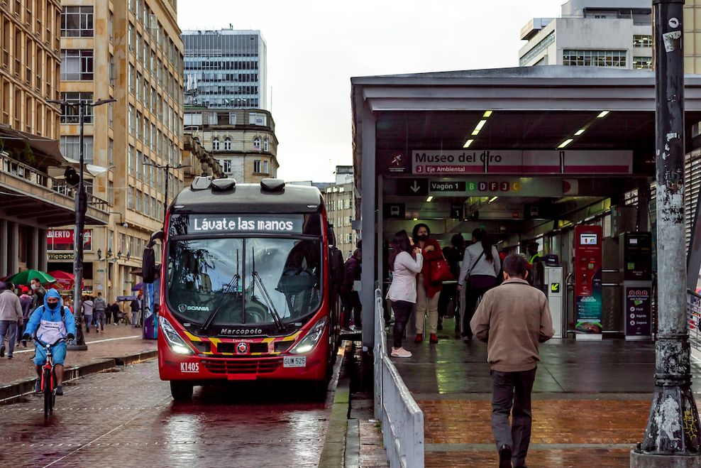
Example of an enclosed BRT station in Bogota with fare gates and fare machines. (G Leo Gue/Shutterstock)
Yes, currently, approximately 22 km of SkyTrain extensions comprising a total of 14 additional stations are under construction. This includes the six-km-long, six-station Millennium Line Broadway extension, set to open in Fall 2027, and the 16-km-long, eight-station Expo Line Surrey-Langley extension, scheduled to open in late 2029. Notably, this marks the first time the region has undertaken two separate SkyTrain extension projects with overlapping construction timelines.
By the end of the decade, following the completion of both projects, the SkyTrain network will expand to roughly 102 kilometres in length, serving 68 stations across Metro Vancouver.
Within the first half of the 2030s, if all goes as planned — with the provincial government’s business case, detailed design, and technical work nearing completion — the Millennium Line could be extended further west from Arbutus Station to the University of British Columbia. Beyond that, however, there are currently no additional SkyTrain extensions clearly identified in the project pipeline, a gap that is deeply concerning given the region’s continued growth, long-term public transit needs, and the growing construction costs from inflation with each passing year.
Beginning planning now for a King George Boulevard SkyTrain extension, a Metrotown-North Shore SkyTrain line, and/or a Hastings Street SkyTrain line would ensure these projects are shovel-ready as soon as funding becomes available, accelerating delivery when political and financial conditions align, and significantly reducing future delays and inflationary cost escalation.
However, committing such significant funding to BRT on these three primary regional corridors risks entrenching bus-based infrastructure as a long-term solution, simply to justify the scale of the investment, even if it ultimately falls short of the region’s long-term needs. It is highly unlikely that federal and provincial governments would look favourably on hundreds of millions of dollars in public funding embedded into bus-oriented roadways being torn up or rendered obsolete within the short to medium term.
TransLink’s BRT concept includes elements such as traffic-signal priority and physically separated, bus-only lanes along nearly the entire length of the corridors, with a stated preference for locating these lanes in the centre of the roadway rather than replacing curbside lanes. The concept also calls for substantial BRT stations that closely mimic street-level LRT station designs, complete with enhanced passenger amenities and features. A public consultation survey earlier this year even explored the possibility of designing BRT stations with fare gates, underscoring the level of permanence being contemplated for this bus-based infrastructure.

Potential concept of TransLink’s Bus Rapid Transit (BRT) services. (TransLink)
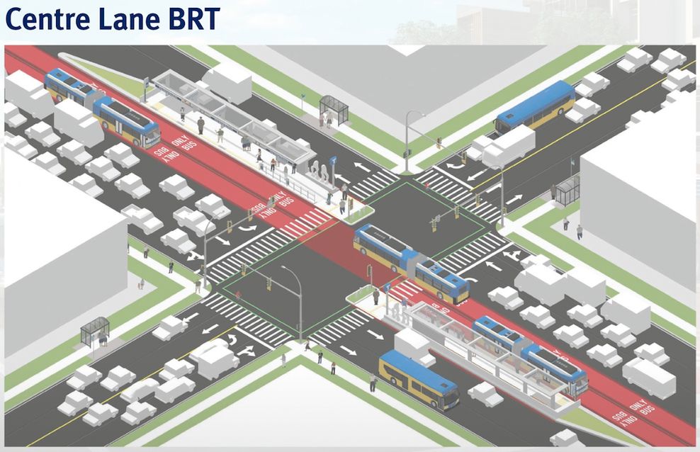
Proposed preliminary concept for TransLink’s Bus Rapid Transit (BRT) lines. (TransLink)
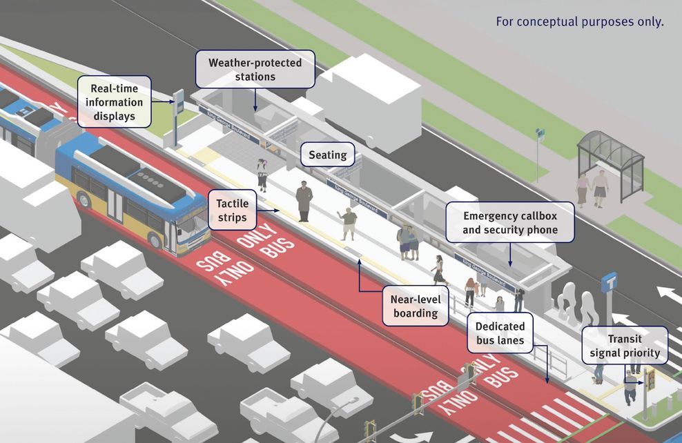
Proposed preliminary concept for TransLink’s Bus Rapid Transit (BRT) lines. (TransLink)
Taken together, this level of investment risks overbuilding BRT in a way that ultimately reduces the likelihood of future SkyTrain implementation along these important corridors. Moreover, a significant portion of these investments would not be required — or directly transferable — for preparing a SkyTrain right-of-way. On balance, a far more moderate approach to bus upgrades would be more appropriate, comparable in scale to the more targeted bus infrastructure investments recently made along Scott Road and 72 Avenue for the R6 RapidBus — a scope of investment that is more suitable for near term needs, just ahead of the far larger investment on the real permanent solution. The R6 RapidBus infrastructure, for a route spanning about 12 km, had a total cost of $33 million.
Alternatively, the $500 million to $600 million currently earmarked for King George Boulevard BRT and Metrotown-North Shore BRT could be redirected toward other BRT projects on corridors that are not primary regional routes, where bus-based rapid transit is sufficient and cost-effective over the long term. Instead, more modest investments would be made to improve the existing R1 King George Boulevard RapidBus and R2 Marine Drive RapidBus services to help resolve immediate issues and further build up ridership on the corridors ahead of building real permanent solutions.
Good transportation planning cannot be dictated by short-term, four-year municipal political cycles, yet too often major infrastructure approaches — whether it be LRT or BRT on some of the region’s most important corridors — are shaped by the urgency of electoral timelines rather than long-term regional needs.
When projects are selected primarily because they can be announced, funded, or partially delivered within one or two terms in office, the result is a bias toward expedient, incremental solutions instead of infrastructure that will serve the region for generations.
Rapid transit systems require decades of foresight, consistent policy direction, and sustained investment. Allowing political cycles to drive mode choice risks locking the region into suboptimal solutions that are difficult and costly to reverse, undermining the very goals of reliability, capacity, transportation mode shift, and long-term economic growth.
There is also a clear lack of leadership and defined vision in the region’s current transportation planning framework. TransLink’s Mayors’ Council plan on rapid transit remains vague, offering few specifics on future rapid transit corridors, timelines, or mode choices, and providing little strategic guidance beyond the projects already underway. Without a clearer, more ambitious vision, the region risks drifting from one short-term decision to the next, rather than advancing a coherent, forward-looking public transit network that matches Metro Vancouver’s growth and aspirations.
This ambiguity is also evident in planning for North Shore rapid transit, where the stated intention is to study a long-term permanent solution — which may or may not be SkyTrain or LRT — while BRT is simultaneously being advanced and implemented as the potential short- and medium-term solution.
If there is the political will, there is a way — but that requires clarity and consistency, not mixed signals or constantly shifting messaging. And when an organization has a clear north star, it is remarkable what can be achieved, even if it takes longer.
TransLink has pledged to conduct some high-level preliminary planning for rapid transit solutions on various corridors, including Hastings Street. But it lacks a certain gusto.
With the world’s most successful rapid transit networks, there is generally a clear acceptance that one mode serves as the backbone of the entire public transit network, providing the primary arterial capacity on which everything else is built. Rather than re-litigating the mode choice for every corridor or project, those regions focus on extending and strengthening that backbone over time, creating certainty for planning, funding, and the public alike.
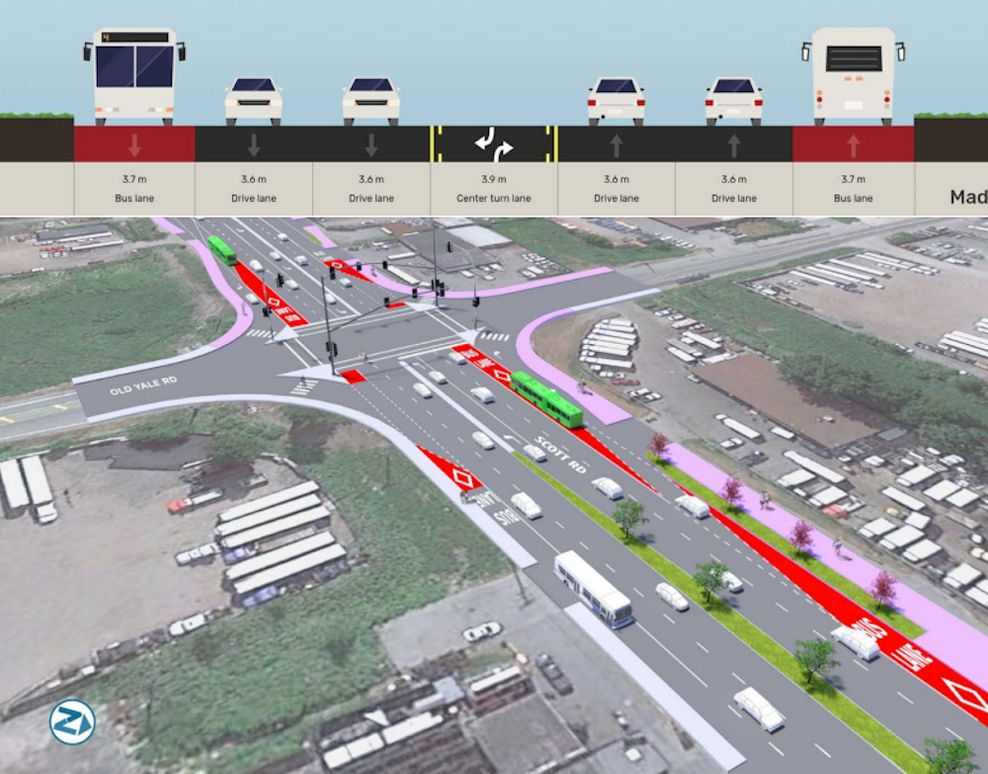
Configuration of bus infrastructure at the intersection of Scott Road and Old Yale Road for the R6 Scott Road RapidBus. (TransLink)
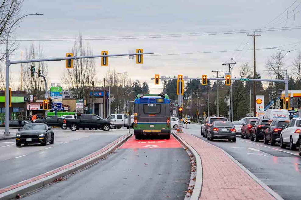
R6 Scott Road RapidBus bus lanes. (TransLink)

R6 Scott Road RapidBus bus lanes. (TransLink)
In an effort to build support for BRT, some have suggested that it is comparable to SkyTrain. This comparison does not hold up at all. And this language problematically treats BRT as a substitute.
While BRT can offer big improvements over conventional bus service, it will not match SkyTrain in terms of the combination of speed, capacity, reliability, scalability, or its ability to shape long-term travel behaviour and land use. Treating the two as equivalent risks blurring important distinctions between fundamentally different modes, with very different long-term outcomes for the region.
Metro Vancouver’s approach to rapid transit has long been regarded as a model for North America, demonstrating how consistent investment in high-quality, fully grade-separated, automated rail can deliver strong ridership, shape land use, and provide a true alternative to driving. That was an overwhelming focal (bragging) point in 2019, when TransLink hosted the Rail-volution conference held in Vancouver, which was attended by over 1,000 delegates from the North American public transit industry, including leaders and planners in many other public transit authorities.
Retreating from this approach by prioritizing lower-capacity, stopgap solutions on primary corridors risks undermining that success. Once the region begins compromising on the quality of its rapid transit backbone, it risks losing the clarity and coherence that have made SkyTrain a standout example of how to build, operate, and grow a rapid transit network in the North American context.
It is difficult not to feel a great sense of envy when looking east at projects such as Montreal’s massive REM network or Toronto’s future Ontario Line — both of which are directly modelled after and inspired by Vancouver’s SkyTrain network, with the use of full grade-separation and automation.
Metro Vancouver risks falling behind by hesitating to clearly define, protect, and advance its next generation of SkyTrain corridors, even as it faces the same rapid population growth, network capacity constraints, and limited road space that pushed Toronto and Montreal to commit to transformative projects like the REM, Ontario Line, and GO Train modernization.
Few infrastructure investments in Metro Vancouver have delivered as much lasting value over 40 years as SkyTrain. The next 10 years will bring another period of transformative change, with the Broadway extension, Surrey–Langley extension, and likely UBC extension reaching completion and carrying the system to its first 50 years. The more pressing question is what comes next — where will SkyTrain go beyond 2035?
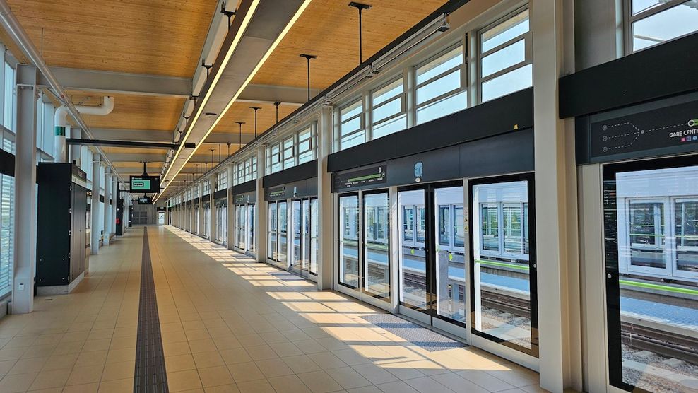
REM metro station with platform screen doors in Montreal. (Kenneth Chan)
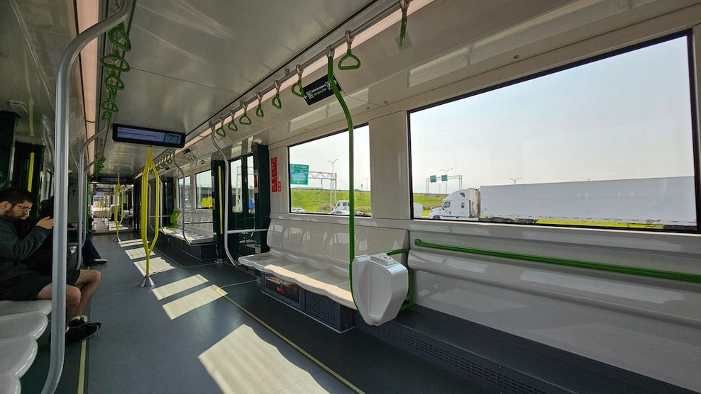
REM metro train in Montreal. (Kenneth Chan)
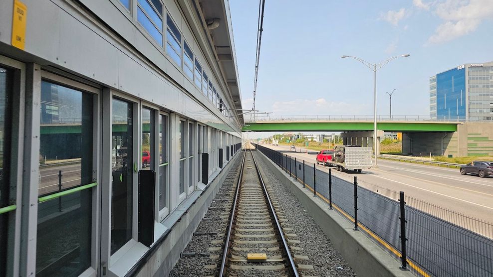
Montreal’s new fully-automated REM metro line running down the centre median of a highway. (Kenneth Chan)
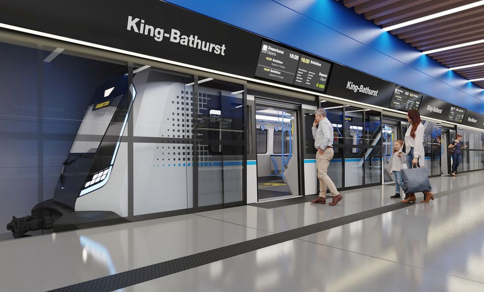
Artistic rendering of the trains and platform screen doors of Toronto’s new Ontario Line. (Metrolinx)
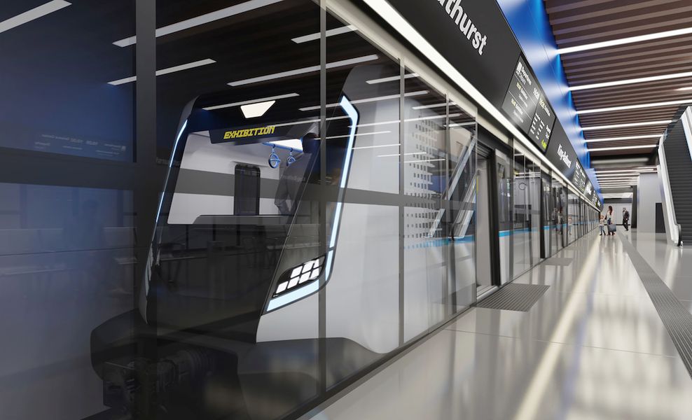
Artistic rendering of the trains and platform screen doors of Toronto’s new Ontario Line. (Metrolinx)
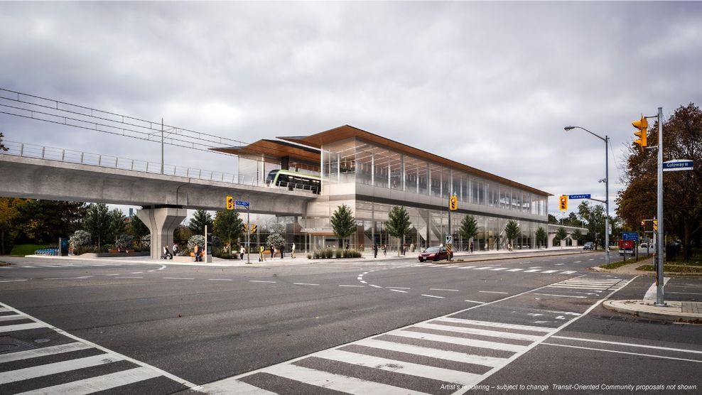
Artistic rendering of an elevated station on Toronto’s new Ontario Line. (Metrolinx)
Artistic rendering of an elevated station on Toronto’s new Ontario Line. (Metrolinx)
- You might also like:
- Opinion: Don't waste time and money on BRT or LRT, begin planning for North Shore-Metrotown SkyTrain
- Opinion: UBC SkyTrain must be Metro Vancouver's next public transit priority
- Opinion: SkyTrain expansion is unquestionably Metro Vancouver's way forward
- Opinion: If TransLink builds Bus Rapid Transit, it must be done right
- Opinion: Why the Hastings SkyTrain and North Shore SkyTrain lines should be built together
- 35 facts you might not know about SkyTrain
- 21 facts about SkyTrain's Millennium Line